Ruthin
 Ruthin
castle is a most odd structure. It may have existed from an early
date, but there is no reference to the fortress before 1212, when it
was in the hands of King John (1199-1216). Etymology suggests that the name Ruthin comes from rudd and
din - the red fort in Welsh. This may suggest a prehistoric origin,
similar to that suggested at nearby Caergwrle or Hope castle. The
cantref of Dyffryn Clwyd, of which Ruthin appears the centre, was
originally a part of Powys. During the Saxon era English settlers
had pushed far to the east and settled the plain as far as Rhuddlan
which appears in the Domesday Book of 1086. However, the
Anglo-Normans seem to have left the hill country north and east of Denbigh
and Ruthin to the local Welsh who probably owed their allegiance to
Powys. During the early twelfth century this region was a
battleground between the forces of Powys, often in alliance with the
earls of Chester, and Gwynedd. By 1165 Prince Owain ap Gruffydd
of Gwynedd had won this battle and sealed his ascendancy by building a
castle at Ewloe, some 7 miles east of Chester and 12 miles north-west of Ruthin. He also built a castle at Tomen y Rhodwydd,
just 6 miles south-east of Ruthin. This strongly implies his
control of Dyffryn Clwyd and Ruthin. On Owain's death in 1170,
Ruthin passed under the control of one of his younger sons, King Dafydd
ap Owain of Rhuddlan. After some vicious fighting, which included the long siege and eventual fall of Denbigh castle in 1196, Dafydd was overcome by his nephew, Llywelyn ab Iorwerth (d.1240).
Ruthin
castle is a most odd structure. It may have existed from an early
date, but there is no reference to the fortress before 1212, when it
was in the hands of King John (1199-1216). Etymology suggests that the name Ruthin comes from rudd and
din - the red fort in Welsh. This may suggest a prehistoric origin,
similar to that suggested at nearby Caergwrle or Hope castle. The
cantref of Dyffryn Clwyd, of which Ruthin appears the centre, was
originally a part of Powys. During the Saxon era English settlers
had pushed far to the east and settled the plain as far as Rhuddlan
which appears in the Domesday Book of 1086. However, the
Anglo-Normans seem to have left the hill country north and east of Denbigh
and Ruthin to the local Welsh who probably owed their allegiance to
Powys. During the early twelfth century this region was a
battleground between the forces of Powys, often in alliance with the
earls of Chester, and Gwynedd. By 1165 Prince Owain ap Gruffydd
of Gwynedd had won this battle and sealed his ascendancy by building a
castle at Ewloe, some 7 miles east of Chester and 12 miles north-west of Ruthin. He also built a castle at Tomen y Rhodwydd,
just 6 miles south-east of Ruthin. This strongly implies his
control of Dyffryn Clwyd and Ruthin. On Owain's death in 1170,
Ruthin passed under the control of one of his younger sons, King Dafydd
ap Owain of Rhuddlan. After some vicious fighting, which included the long siege and eventual fall of Denbigh castle in 1196, Dafydd was overcome by his nephew, Llywelyn ab Iorwerth (d.1240).
On 12 August 1211, Prince Llywelyn ab Iorwerth (d.1240) quitclaimed the Perfeddwlad to his father in law, King John
(1199-1216). In this he specifically mentions the cantref of
Dyffryn Clwyd with Ruthin. He similarly mentions Rhufoniog with Denbigh.
The implication is that there might already have been a castle in both
places. However, in the same document he granted John the castle
of Degannwy with Rhos, while no castles are mentioned at Ruthin or Denbigh. By 26 July 1212, Robert Vipoint, the lord of Appleby, Brough, Brougham and Pendragon on the Scottish borders, was heavily besieged in Mathrafal castle and had to be rescued by King John and a small cavalry army by 6 August. Robert also had the castles of Oswestry, Chirk, Eggelawe (Kinnersley or Ewloe) and Carreghofa in his custody at this time.
In October 1212, King John granted the Perfeddwlad, except for Degannwy castle,
to King Dafydd's son, Owain ap Dafydd and his cousin Gruffydd ap
Rhodri. Again no mention was made of other castles in this
district. However, in the Shropshire pipe roll of September 1212
an expenditure of 3m (£2) was made for nails at Rufin castle. As much more expensive works were also carried out at Chirk, Holywell, Llanarmon yn Ial and Mathrafal castles in this same district, it seems most likely that this Rufin was Ruthin castle, rather than Bryn Amwlg
45 miles to the south as has also been suggested. This point is
reinforced by the respective distances from these places to Ruthin or Bryn Amwlg, viz Chirk 16 or 35; Holywell 12 or 57; Llanarmon 4 or 44 and Mathrafal 26 or 19. Also no mention is made of the other Fitz Alan castles nearer to Bryn Amlwg, viz. Clun, Shrawardine or Oswestry.
Presumably the large amount of nails - £2 was an infantryman's
annual wage in 1200 - were sent to Ruthin for woodwork. Hence
this might have been for making palisades or scaffolding for masonry
work. However, the money being spent at the other threatened
castles ran into hundreds of pounds.
Despite the king's efforts, before 1212 was out all the castles of the Perfeddwlad bar 3 were back in Llywelyn's hands. These 3 were Degannwy, Rhuddlan and Basingwerk/Holywell. Quite obviously from this, Ruthin and Denbigh
were back under Llywelyn's control. Finally the king's 3 northern
castles fell to Llywelyn in 1213 and the prince and his allies pressed
ever eastwards taking Tafolwern and Carreghofa during the same year. This left Oswestry and Shrawardine
as the royalist held castles nearest to Ruthin. Subsequently the
Perfeddwlad remained in Welsh hands for the rest of the reign of Prince
Llywelyn (d.1240).
In 1247 control of Ruthin was acknowledged as belonging to King Henry III
(1216-72), although he is never recording as being involved in the
running of the town. In 1254 the king granted his son, the Lord Edward (d.1307), all the Perfeddwlad including Ruthin. However, the land was rapidly overrun in November 1256 by Prince Llywelyn ap Gruffydd, leaving only Edward's castles of Degannwy and Dyserth
holding out until 1263, Dyserth falling on 4 August and Degannwy on 28
September. In the midst of this final attack on the Perfeddwlad,
Edward granted his cantrefs of Dyffryn Clwyd and Rhufoniog to Dafydd ap
Gruffydd (d.1283) on 8 July 1263, although the grant must have proved
abortive.
In the Summer of 1277, Edward (d.1307), now as king of England, invaded
the Perfeddwlad and reclaimed Ruthin. Therefore that July or
August the king's clerk, William Blyborough, was given £20 to go
to Ruffyn to build Ruffin castle. Whatever he was doing at Ruthin seemed to be finished by 7 November 1277 when 120 diggers arrived at Rhuddlan
from Ruthin. Presumably they had been working at Ruthin since
July or August and that work had ceased either because their work was
done, or the lordship and castle had been turned over to Dafydd ap
Gruffydd (d.1283) for the lifetime of his brother, Prince Llywelyn ap Gruffydd (d.1282). The order confirming the king's renewal of his grant of 8 July 1263 was made patent on 10 October 1277 at Rhuddlan. According to the agreement, on Llywelyn's death Dafydd was to receive his share of Gwynedd and return Denbigh and Ruthin to the Crown.
On the rebellion of Dafydd ap Gruffydd (d.1283) in March 1282 the
castle was subdued in August, siege engines called ‘Pyceyns' and
‘Howans' having been taken from Chester
to Ruthin as early as 22-23 August. The king himself stayed at
Ruthin from 31 August to 8 September. It appears some
insignificant work may have taken place at the castle as the rather
measly sum of 5d was spent on Master James the engineer buying clays at
Ruthin (Ruffyn). By 21 October King Edward had obviously granted Ruthin castle and its cantref to Reginald Grey of Wilton
(d.1308) as Reginald wrote that day from Ruthin to Bishop Robert
Burnell of Bath and Wells (1274-92). In the letter Reginald
explained that the king had visited him this very day ‘to view
his works and the things that Grey was doing there'. Edward also
told Grey to chase up the matter of the charter for his new lands with
the bishop - hence his letter. The charter granting Reginald
Ruthin castle with the cantref of Dyffryn Clwyd and the lands of
Gwenllian Lacy in Englefield was issued at Denbigh on 23 October 1282.
Grey remained in control of Ruthin for the next 12 years, but during Madog ap Llywelyn's rebellion of 1294, Denbigh, Ruthin, Mold and Hawarden
castles all fell to the rebels. Probably they were all merely
pillaged although the Worcester chronicle states that they were all
'wasted to their foundations'. As the castles obviously weren't
utterly destroyed this probably means that they were merely
pillaged. Ruthin castle was attacked by Glyndwr's cavalry on 17
September 1400 as he swept through the North-West Welsh castles, but
only the town was sacked. Finally the castle withstood an 11
month siege in 1646 and was then slighted by parliament. In 1826
the current mansion was begun and the ruins embellished in Gothic style.
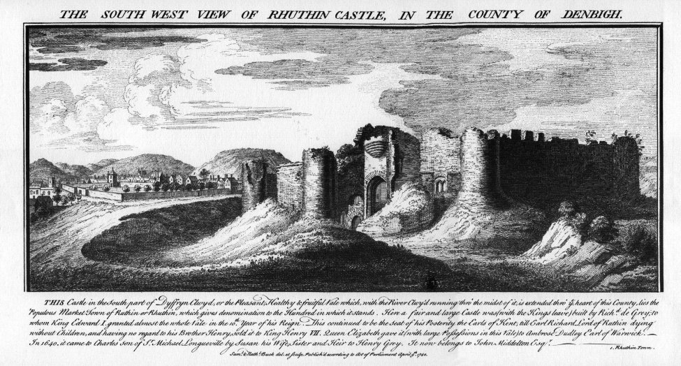
Description
As ever we may turn to Wikipedia for a full and erroneous tale of Ruthin's foundation: viz
the castle 'was constructed during the late thirteenth century by
Prince Dafydd ap Gruffydd'. The natural rejoinder to this 'fact'
is the obvious statement that the castle is of 2 or more distinct
builds. The history given above more suggests that an original
Welsh castle was built at Ruthin before 1212 when it came into royal
hands. Much later in 1277 King Edward I
(1272-1307) spent a relative pittance at Ruthin on his ditching.
It then passed to Dafydd ap Gruffydd (d.1283) who may have added the
somewhat odd lower ward. In 1282 the fortress fell to Edward
again and once more he spent a pittance on the structure before handing
it over to Reginald Grey (d.1308) who carried out his own works there
which seem to have been quite substantial. The most likely
scenario therefore seems to be that the red sandstone castle was the
work of a Welsh prince in, or after the time of King Dafydd ap Owain of
Rhuddlan (d.1200) and before the fortress
fell to King Edward in 1277. The upper storeys of the upper ward
and may be the bulk of the lower ward, if that was not constructed by
Dafydd ap Gruffydd (d.1283), were made in a light grey sandstone and
therefore probably date to the time of Reginald Grey (d.1308). The whole castle was once surrounded by a
wet moat and apparently a large pool to the north and west.
Upper Ward
The upper ward is pentagonal about 180' across and 280' at its maximum
extent from the north-east apex tower to the line of the curtain under
the Victorian hotel. Four of the points of the pentagon were
marked by roughly 25' diameter D shaped towers, the western 2 surviving
towers being apparently open backed, while the northern tower was
circular rather than U shaped. Indeed the northern tower, what
little remains of it, rather resembles the end towers at Ewloe or Carndochan
and is made of a mix of mainly grey sandstones interspered with the odd
red block. Further, the masonry style is poor with much small
shattered stones making up the gaps between courses. Indeed it is
more reminiscent of granite work in Criccieth castle
than the rest of Ruthin's stonework. Possibly it was refaced in
the Victorian era, or is much older than the rest of the castle.
The east angle of the upper ward, instead of boasting a single tower like the other 4 corners, possessed a fine, twin towered gatehouse
some 70' across and 50 deep. This has been much ruined, but the
impressive stairway leading down into both towers is reminiscent of Wilton castle
in Herefordshire which was owned by the same Grey family that owned
Ruthin from 1283. The gate towers are elongated D structures, now
reduced to pretty much only the basements, with the bases of the rear
walls built of the local red sandstone. The 20' deep moat
guarding the approach to the gatehouse has been filled in along this
front, no doubt to allow easier access to the 1820s mansion. The
southern gatetower was also raised in height at this time and
‘the hall' rebuilt. The gatehouse basement, to accommodate
the rebuilding above, has been given a Victorian barrel vault, however
a mutilated embrasure remains to the east. To the north a
triangular late thirteenth century passageway, containing steep steps
similar to those found in Goodrich and Wilton
castles and leads down to the basement. In that chamber another
triangular headed passage links the 2 gatetowers together underneath
the gate passageway. This is a most unusual feature. The
north gatetower has been much ruined and the portion that survives
above ground appears a Victorian rebuild as the walls, a single course
thick above current ground level, cannot be original. The steps
down into the basement, similar but narrower to their compatriots to
the south, would seem to be original. The doorway into this
passageway is made of red sandstone and is most unusual in conception,
bearing some comparison with the doorway into Peak castle keep.
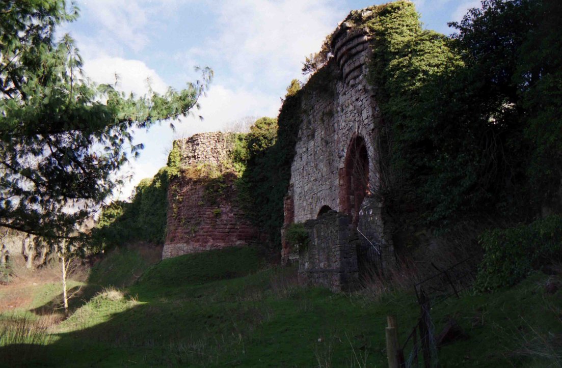
South of the gatehouse the base of the curtain is quite well preserved
and the wide moat apparent. Just before the wall has been
destroyed by the building of the mansion what appears to be a
projecting turret can be made out. The fine red sandstone batter
is readily apparent here. The south east tower of the inner ward
has disappeared under the mansion, as too has the south east tower of
the lower ward beyond.
The interior of the ward has been raised some 20' from the
exterior. Probably this infilling is from the 1820s. Along
the north-west wall are the alleged remains of the hall. As
noted, the interior of the castle has been infilled which suggests,
together with all the reused material in walls, that all this odd, long
structure is a Victorian rebuild as are the windows, buttresses and
battlements along this front. The 2 western towers of the inner
ward appear residential at internal ground floor level, both showing
evidence of window embrasures with seats. The lower floor and
possible basement have been infilled, possibly similarly to what
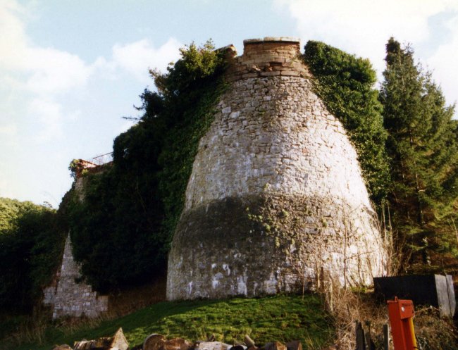
occureed at Chinon castle in Anjou. A glance at the external masonry of the west tower shows that its
first 20' is made of the local deep red coloured sandstone. This portion of the
tower would seem to have been infilled and a new tower constructed upon
the summit in a totally different grey sandstone. Standing within the
tower it is obvious that the new work is on a slightly different
alignment to that underneath. The lower tower is D shaped within and
without, while the grey stone upper floor is set within the lower wall thickness and has a
polygonal interior and several window embrasures, features totally
lacking from the structure below. Both
western towers have stair vices in their junctions with the curtains,
while from the south-west tower a modern flight of steps, possibly on
the site of an original stair, descend towards, but do not reach the
original ground level of the lower ward. Most likely the largely
destroyed upper storeys of these towers, built in grey stone on the
older red sandstone structures, was the work of Reginald Grey after
1282.
Lower Ward
To the south-east of the main ward lies a second or lower ward.
This is rectangular, about 200' east to west by 170' north to south and
has been much damaged. The west wall survives virtually intact as
too do the lower floors of the open backed D shaped west tower,
although the plinth at its bottom looks suspiciously like Victorian
work. The ‘moat' which runs from the west tower of the
inner ward to the hotel to the east would appear to actually be the
space where the interior of the castle has not been infilled as
elsewhere when the Victorian mansion was constructed. This trench
is now called the moat and itself is partially infilled judging by the
entrance level at the west gateway which feeds into the lower
ward. To the north the moat is bounded by a scarp on which stands
some 25' of the south curtain wall of the inner ward. To the
south is a Victorian wall 20' high and holding the infill back from the
ditch. A similar amount of infill can be found in the inner
ward. Some half way along the south wall of the upper ward is a
passageway leading under the curtain. The walls on either side
are well cut red sandstone, but the roof is a jumble of later grey
stone. Presumably this is a part of the old work, buried under
the new.
A flight of stairs running down to the lower level south of the central
tower in the west wall, appears to lead to a blocked sally port with a
highly pointed doorway, all made of the red sandstone. This has
been inserted into a blocked slightly pointed arch, reminiscent of the
main gate arch at Wigmore castle. The sallyport passageway behind is somewhat reminiscent of the odd sallyport at Denbigh castle
by the Bishop's Tower. Between the sallyport and the west gateway
is a large, 12' diameter, Romanesque archway, set next to the exposed
bedrock the curtain is built upon. Within this is a smaller
triangular topped archway which appears to be the exit chute of a large
garderobe. Quite what this fed from is uncertain, but presumably
there were once major living quarters within at this point.
Why
not join me at other Lost Welsh Castles next Spring?
Please see the information on tours at Scholarly
Sojourns.
Copyright©2017
Paul Martin Remfry