Carndochan
 According to Wikipedia
Carndochan:
According to Wikipedia
Carndochan:
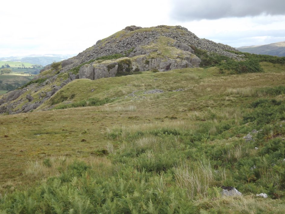
castle stands on a ridge
overlooking the Lliw Valley; its early history is unrecorded, but it is
thought to have been built by Prince Llywelyn ap Iorwerth between 1215
and 1230. Little is known of the site's history although King
Edward I of England visited in 1283–84.
In reality few castles are known to have been
built by Prince Llywelyn. A paper, taken from Harlech Castle and its True Origins,
summarising the evidence for this can be found here.
Carndochan lay in the commote of Uwch Tryweryn in the
cantref of Penllyn. As such the castle was held by the kings of Powys
until 1160 when King Madog ap Maredudd died at Whittington castle.
His son Elise then held Penllyn until 1202 when he was
dispossessed by Llywelyn ab Iorwerth who was attacking Powys.
As a
consequence Elise was forced to retire to the commote of Edeirnion,
north
of Bala, which is based around Corwen and Rug castle.
According
to the Welsh Chronicles, Elise was allowed to retain 'for his
sustenance a castle called Crogen
and seven small townships along with it'. As Crogen was in Is
Tryweryn, due east of Bala, it would seem that Elise managed to keep
the
eastern part of his domains as the chronicles announced with glee
Llywelyn's taking and maintaining of Bala castle. As Crogen
lies
6 miles SE of Bala, towards Powys
which was friendly to Elise, it seems natural for him to be forced back
in that direction.
 This leaves the question as to why Llywelyn, holding Bala
castle,
would then fortify the remote highland site of Carndochan where no one
was likely to attack him? The only feasible route of attack
here comes either from Gwynedd to the north or from Bala down lake
Tegid. Carndochan therefore seems to protect solely against
attack from Gwynedd or Meirionydd, which Llywelyn had conquered before
attacking Penllyn. The style of the castle too makes it most
unlikely that a
prince of Gwynedd would have built this castle after Llywelyn's death
in 1240. This therefore leaves the logical answer
that
Carndochan was built by the princes of Powys, a more Anglophile
princely family, who were well known for building and reusing castles,
viz, Carreghova (1187), Cymer
(1116), Dinas Bran
(1187), Edeirnion/Rug
(1160), Oswestry (1149), Powis
(1111), Tafolwern (bef.1162),
Whittington
(1149). The castle therefore seems meant to protect Powys
from agression by the princes of Gwynedd, not by the princes of Gwynedd
to threaten distant Powys.
This leaves the question as to why Llywelyn, holding Bala
castle,
would then fortify the remote highland site of Carndochan where no one
was likely to attack him? The only feasible route of attack
here comes either from Gwynedd to the north or from Bala down lake
Tegid. Carndochan therefore seems to protect solely against
attack from Gwynedd or Meirionydd, which Llywelyn had conquered before
attacking Penllyn. The style of the castle too makes it most
unlikely that a
prince of Gwynedd would have built this castle after Llywelyn's death
in 1240. This therefore leaves the logical answer
that
Carndochan was built by the princes of Powys, a more Anglophile
princely family, who were well known for building and reusing castles,
viz, Carreghova (1187), Cymer
(1116), Dinas Bran
(1187), Edeirnion/Rug
(1160), Oswestry (1149), Powis
(1111), Tafolwern (bef.1162),
Whittington
(1149). The castle therefore seems meant to protect Powys
from agression by the princes of Gwynedd, not by the princes of Gwynedd
to threaten distant Powys.
Presuming the castle was built by 1202 it obviously fell to Prince
Llywelyn that year. Possibly the prince sub-infeudated the
castle, for on 7 August 1281, when Prince Llywelyn ap Gruffydd (d.1282)
found his new frontier in Penllyn, he seems to have tried to acquire the
castle. It is possible that Carndochan had been given to
Tewdwr ab Ednyfed in the 1240s or 1250s. Certainly Prince
Llywelyn claimed he had given Pennant-lliw to Tewdwr when he swapped it
back with Tewdwr's son, Heilyn, in August 1281. Pennant-lliw
was a township in Penllyn in which Carndochan castle lay. The
implication of this might have been that Llywelyn was taking the
fortress back over to help defend his new frontier during a time of
increased tension between Llywelyn and his Powysian neighbours to the
south and east. This would also have given King Edward a
reason to look over the fortress in 1283.
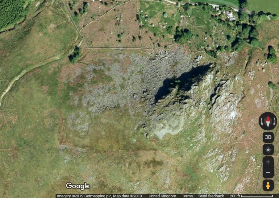 Description
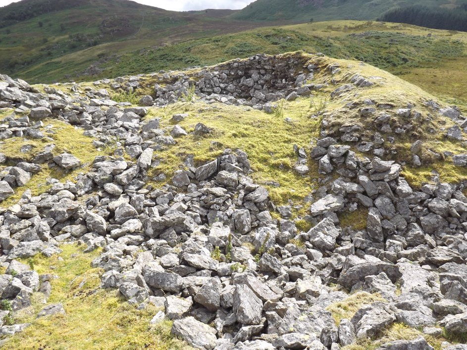
The castle remains have recently been partially excavated which
confirms much of the castle's plan. The centre of the
fortress was a keep, 35' square, built on the turf
overlying the bedrock. Such a 'foundation' strongly suggests
a quick Welsh build. There are several keeps of similar
dimensions in England; Bridgnorth (38'x35'), Clitheroe (35' square),
Clun (30' square), Farnham (37' square), Goodrich (29' square),
Hyssington (27' square), Moreton Corbet (38'x33'), Peveril (21'x19'),
South Mymms (35' square), Wattlesborough (30' square), Whittington
(52'x38') and some in Wales, Criccieth (43'x32'), Dinas Emrys
(36'x27'), Dolwyddelan I (25'square?), Dolwyddelan II (44'x31'), Usk (35' square), White Castle (35' square) and Castell Y Bere (50'x35'). The tower was surrounded by a bow shaped
ward with a round tower to the NE. To the south was an
entrance, of which the pointed arch still survived collapsed into the
gatepassageway, flanked some way to the east by a D shaped tower and by
an elongated D shaped tower similar to those of Ewloe
and Y Bere. There
was a rock cut ditch to the SW, but nothing around the rest of the site
which just relied upon the steep slope for defence. No
dateable finds were found within the castle other than a fifteenth
century token. Evidence found in Victorian excavations and in
the present one, suggest that the keep at least was destroyed by fire.
As Edward I did visit... it is to be presumed it was fired
after this date, unless it had been destroyed by its garrison in 1282
like Criccieth and Harlech. In which case Edward was probably assessing whether it should be reused like the above two castles,
or abandoned. There would also appear to be a ditched platform
with rounded corners surrounding the castle, about 700' E-W and 600'
N-S. Possibly this is an unrecognised site of a Roman fort.
Copyright©2019
Paul Martin Remfry