Calatubo
The castle may have been in existence by 1093 when Count Roger Hauteville
(d.1101) defined the boundary of Mazara diocese which included
‘Calatubo with all its dependencies'. By 1154 the district
around the castle was being quarried for stone for mills. During
the reign of Frederick II
(1198-1250) the surrounding village was abandoned and the castle
converted into a farm and was then modified again to house a wine
making facility at the end of the nineteenth century. The castle
was finally ruined in 1968 by an earthquake and subsequent treasure
hunters who were digging to loot prehistoric burials.
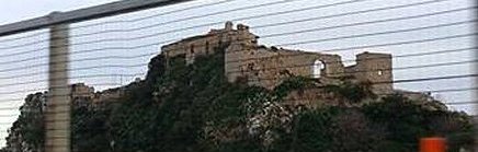
Description
The castle is about 750' long by 110' wide on an east to west running
limestone ridge in typical Byzantine fashion. Such
‘Byzantine' ‘battleship' sites are listed under Aci castle.
The main portion of the site consists of the high crag running from
east to west along the site, being no more than 30' wide at its
maximum. On this the main castle was built - there still being
traces of the internal south wall on the rock top amongst the later
wine making buildings and traces of a Norman keep standing on the
highest part of the crag. To the south of this is the larger
outer ward lying on the lower cliff face.
The main defences lie to the west where the castle was easiest to
approach. A single rectangular tower stands in the most exposed
southwest corner guarding the approach road. Another to the
northwest has partially collapsed, while between then lay a gate, now
much widened, but originally protected by at least 2 crossbow
loops. Before this lay a barbican with a possible rectangular
tower to the northwest.
The remains of what appears to be another rectangular tower lies to the
south, while a tower with a beaked spur stands in the northeast corner.
Why not join me here and at other Sicilian
castles? Information on this and other tours can be found at Scholarly
Sojourns.
Copyright©2019
Paul Martin Remfry