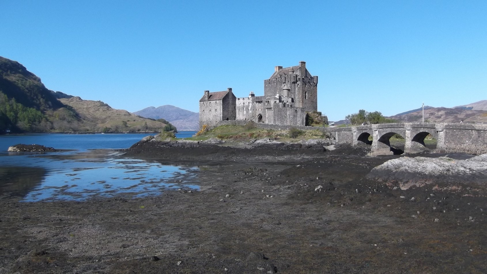
Eilean Donan Castle
Eilean Donan, which means the isle of Donnán, is a small tidal
island where three lochs meet, Loch Duich, Loch Long and Loch
Alsh. In the West Highlands of Scotland the castle is one of the
most photographed monuments in the British Isles and is a recognised
Scottish icon, frequently appearing on packaging and advertising.
The castle itself has made several film appearances, beginning with
Bonnie Prince Charlie in 1948 and The Master of Ballantrae in
1953. The castle was the setting for the 1980 short film Black
Angel and featured prominently in Highlander (1986); was backdrop to a
scene in Kuch Kuch Hota Hai in 1998; served as the Scottish HQ of MI6
in The World Is Not Enough in 1999 and stood in for Fotheringhay castle
in Elizabeth: The Golden Age.
History
Eilean Donan is supposedly named after Donnán of Eigg, a Celtic
saint martyred in April 617, who is said to have established a church
on the island. It is thought that some fragments of vitrified
stone that have been discovered indicate the presence of an Iron Age or
early medieval fortification.
It is held that during the reign of Alexander II (1214–1249) a
large enclosure castle was constructed on Eilean Donan island. At
this time the area marked the boundary between the lordship of the
Isles and the earldom of Ross. In reality there is no certainty
as to when this wall and the undoubted buildings that once lay within
were constructed. Later in the century the island was possessed
by the Mackenzies of Kintail, who were originally vassals of Earl
William of Ross (1251-74). It is stated, without contemporary
evidence, that after the Treaty of Perth of 1266, by which King Magnus
VI of Norway ceded the Hebrides to King Alexander III, Earl William
demanded that his kinsman, Kenneth Mackenzie, return the castle to
him. Mackenzie refused, and Earl William led an assault against
Eilean Donan that the Mackenzies and their allies repulsed. The
Mackenzie clan histories also claim that Robert the Bruce sheltered at
Eilean Donan during the winter of 1306 to 1307 - although the castle is
not known to have been involved in the Wars of Scottish
Independence. Indeed much is written about the ‘history' of
the castle that does not appear in any original source.
The first solid history to be attached to the castle is found in the
civil wars of the mid seventeenth century when the earl of Seaforth sided with
Charles I (1625-49). In 1650, after the king's execution, the
parliament of Scotland ordered a garrison put into Eilean Donan.
The local people did not welcome this and when a party of 30 soldiers
came out from the fortress to request provisions from the local people,
a band of 10 men who opposed their demands met them. An argument
broke out, which led to the garrison men being driven off with several
casualties. Shortly afterward the garrison is said to have left.
In 1714, while surveying fortifications for the government, the
military engineer Lewis Petit made the only surviving drawing of Eilean
Donan before its destruction. The sketch, elevation and carefully
drawn plan, show a dilapidated castle, largely roofless but for a small
building by the entrance.
The next year war broke out with a Jacobite rebellion that soon petered
out. However, the rebels found new support from Spain during the
War of the Quadruple Alliance. The duke of Ormonde led the main
invasion fleet from Spain, while an advance party of 300 Spanish
soldiers under George Keith, tenth Earl Marischal, arrived in Loch Duich
in April 1719. His forces soon occupied Eilean Donan
castle. Regardless, the expected uprising of Highlanders did not
materialise, and the main Spanish invasion force never arrived.
Consequently at the beginning of May, the Royal Navy sent ships to the
area and early in the morning of Sunday, 10 May 1719, HMS Worcester,
HMS Flamborough and HMS Enterprise anchored off Eilean Donan and sent a
boat ashore under a flag of truce to negotiate. When the Spanish
soldiers in the castle fired at the boat, it was recalled and all three
ships opened fire on the castle for an hour or so. The next day
the bombardment continued and in the evening, under the cover of an
intense cannonade, a detachment went ashore in the ships' boats and
captured the castle against little resistance. According to the
Worcester's log, in the castle were ‘an Irishman, a captain, a
Spanish lieutenant, a serjeant, one Scotch rebel and 39 Spanish
soldiers, 343 barrels of powder and 52 barrels of musket shot'.
The naval force spent the next two days and 27 barrels of gunpowder
demolishing the castle. HMS Flamborough then took the Spanish
prisoners to Edinburgh, while the remaining Spanish troops were
defeated on 10 June at the Battle of Glen Shiel. This
definitively ended the castle's military history.
Two hundred years later, between 1919 and 1932, the castle was rebuilt
by Lt. Col. John MacRae-Gilstrap. The restoration included new
construction, namely of the arched bridge to give easier access to the
island and a war memorial dedicated to the men of the MacRae clan who
died in the First World War.
Eilean Donan was opened to the public in 1955 and has since become a
popular attraction with over 314,000 people visiting the castle in 2009
- making it the third most visited castle in Scotland.
Description
Although very little historical evidence for the medieval castle
survives, a mapmaker, Timothy Pont (c. 1565–1614), did make a
description:
The castell of Ylen Donen is
composed of a strong and fair dungeon [keep] upon a rock, with another
tower compasd with a fair barmkin wall, with orchards and trees, al
within ane yland of the lenth of twa pair of butts [i.e. archery butts]
almost round. It is sayd of old that castel consisted of seven
tours.
Much of this is verifiable from the current remains, although not all of the 7 towers are now visible.
The first military phase seems to have comprised an irregular curtain
wall enclosing the bulk of the island above the high tide line.
Archaeology has uncovered no trace of an earlier vitrified fort.
As such this seems to be yet another rumour that interesting castles
always seem to attract. The original enclosure contained an area
of around 32,000 square feet. The remains of this wall can be
best seen to the north where there are the foundations of a large
rectangular tower to the north-west, about 39' by 43'. Further
foundations suggest similar towers at the north-east and south-west
corners of the
enclosure. The ward was accessed via a sea gate in the north-west
curtain
wall between the north-west tower and the keep. This overlooks a
small
landing beach where boats could be drawn up and mimics the layout at
various other waterside castles. These are listed under Dunvegan castle. The archaeological
excavations also found evidence of 2 curtain walls to the north.
The first lay towards the north-east angle of the north-west tower, but this was
superseded by another set south of this that measured an incredible 30'
thick, while the remains stood up to 2' high. This wall postdated
the construction of the north-west tower and was built in 2 phases, the first
wall being only 15' thick. Presumably the second phase dated to
the sixteenth or seventeenth century and was concerned with making the castle defensible
against cannon. The dig also found that metalworking had taken
place in the north part of this castle while a great hall stood
nearby. There was probably also a landward entrance towards the
tidal shore, although so far only fragments of the west curtain have been
uncovered.
A towerhouse or keep was built against the curtain wall at the
high point of the island, probably in the fourteenth century. This measured
54' by 41', with walls 10' thick, while the older curtain was used as
part of the foundations of at least the north wall. The vaulted
ground floor was originally divided in two, with a stair in the north wall
giving access to the first floor hall. Above this were probably
another 2 storeys and then a garret. The tower, according to
Petit's later drawing, was topped by crowstep gables and surrounded by
a walkway and bartizans (small turrets) at the corners.
Later, probably around the turn of the fifteenth century, a smaller internal
enclosure, around 80' square, was added in front of the keep upon the
summit of the island. The entrance to this was from the east.
Further development took place within this courtyard in the sixteenth century and
additional defences were added to the east side. Although it is
stated that this new enclosure allowed the old castle curtain around
the shoreline to be abandoned this is not certain. Indeed the
opposite may be true as Pont hints that before 1614 the entire
enclosure seemed to be still fortified as there is surely not enough
room for orchards within just the inner enclosure. However, this
may have been going to ruin judging from Pont's difficulty in knowing
how many towers there originally were. Further, if the outer wall
had been systematically demolished when the inner castle was built,
surely the current remains would have been better demolished to make
sure that the outer defences could not be used as cover by attacking
forces.
During the sixteenth century two buildings were added to the southern periphery of
the enclosure. A small house was constructed within the south-east angle
of the wall. This had a circular stair tower on its north side giving
access to the walkway along the eastern curtain wall. Located
just inside the gate, this is likely to have served as a house for the
castle's constable or keeper, and is the only building shown with a
roof on Petit's 1714 survey. At the south-west corner of the enclosure an
L plan block was put up. The south part is sited outside the line of the
inner curtain wall, with a northern wing, which may have been a
slightly later addition, inside the wall.
In the later sixteenth century the castle was extended to the east to create a
bastion or 'hornwork'. This comprises a pair of 5' thick walls
enclosing a triangular courtyard, linking the east wall of the inner
castle with an irregular hexagonal structure. This ‘tower'
is 38' across and contains a well at its lowest level, some 16' across
and 33' deep. Although it has been described as a water tower or
cistern, the presence of a door on its eastern side, as shown in nineteenth century
photographs, indicates it was built as the main entrance to the inner
castle. The water-filled interior must have been crossed by a
removable bridge, presenting yet another obstacle to attackers.
From the bridge access to the castle would have been up a flight of
steps into the triangular courtyard, and then through the gate in the east
curtain wall. Dredging of the reservoir in 1893 recovered two
brass guns, referred to as 'double hagbuts' and a yett. This iron
gate may have been installed in the east door to the hexagonal bastion and
is now on display inside the castle. At some point in the seventeenth century
this elaborate access was abandoned and a more convenient entrance
opened in the south wall of the hornwork.
Although the twentieth century reconstruction followed the extant ground
plan, the details of the present castle differ from its original
appearance as shown by old drawings and photographs. Today the
castle is entered from the south, via a modern gateway complete with modern
portcullis. Through this is the courtyard, the level of which has
been lowered exposing the bedrock around the towerhouse. The
present buildings to the south-east of the ward reflect the form of the earlier
structures, including the circular stair tower, but are larger in
extent than their medieval forebears. To the south-west only the south
portion of the L shaped block was reconstructed, as a plain 3 storey
house, while in place of the north wing is an open platform giving views
over the loch. The keep itself follows the original dimensions,
though the formerly subdivided ground floor is now a single room.
On the first floor is the banqueting hall and fifteenth century style
fireplace. Small mural chambers within the walls are accessed
from each hall.
Why not join me at Eilean Donan and other Great Scottish Castles this Spring? Information on tours at Scholarly Sojourns.
Copyright©2016
Paul Martin Remfry