Peyrepertuse
Peyrepertuse, with Aguilar,
Termes, Queribus and Puilaurens, were termed
the 'Five Sons of Carcassonne' when they were fortified to protect the 1483 borders of France with Spain.
The name has since stuck and is often applied retrospectively.
The medieval fortress is the largest of the five castles and dates back
to Roman times in the first century BC as shown by excavation.
Despite this, the first references to a castle appear only in 806.
In 988 the castle was passed with the Fenouilledes, including Fenouillet and Puilaurens, to the Catalan
Count Bernard of Besalu (d.1020). According to his 1020, acted upon on his
death by drowning in the River Rhone, Peyrepertuse belonged to him and
his heir,
Count William (d.1052). The castle then passed to Count Raymond Berenger of
Barcelona (d.1131) in 1111 on the death of the last count, Bernard III. It
later passed to the viscountcy of Narbonne judging from the will of
Arnau Fenoled (d.1173), the lord of Tautavel (Talteul)
which was the caput of Besalu. By 1180 it was held by King
Alfonso II of Aragon (d.1195) who was the grandson of Raymond Berenger (d.1131).
As an Aragonese castle, Peyrepertuse was not initally attacked by the
Crusaders in the early 1210s. However, the castle seems to have
been sub-infeudated by the king's of
Aragon to William Peyrepertuse. He surrendered it to the
Crusaders in 1217, although he never seems to have relinquished
control.
In 1224 he rebelled again, was excommunicated, but held the castle for
the Cathar cause until 1240. In that year he and the other rebels
failed to take Carcassonne
and so,
like many other rebels, he surrendered his castle to King Louis IX
(d.1270).
As ever in Pyrenean history, the story was not simple, as others too claimed the lordship of Peyrepertuse. Count Sancho of Roussillon and Cerdanye (d.1223) held various rights throughout the district and in 1226 his son, Nuno Sanchez (d.1242), purchased the
viscounties of Fenouilledes and Peyrepertuse from Louis VIII (d.1228)
and did homage to the French king for them, thereby accepting them as
part of France and not Aragon. Possibly this was to ensure they were
not attacked by the new crusade the king was planning. In 1239 Nuno sold
Queribus and Peyrepertuse
castles to King Louis IX (d.1270) for 20,000 Melgorian sou. No
doubt this aided the king in his capture of the castle in 1240.
Peyrepertuse castle, now a royal holding was ordered to
be strengthened in 1242 and in 1250-1 the St George upper castle was
added higher up the ridge, while the old keep and St Mary's church
below were rebuilt. In 1258 the treaty of Corbeil effectively
split Catalonia from Languedoc and made Peyrepertuse part of the
Franco-Spanish border until 1659. At that time the castle was
downgraded to a small
garrison of only some 9 sergeants. Previously in 1302 the garrison had consisted of the
castellan, 21 sergeants, a scout, a porter, a chaplain and dogs.
Later the local population is responsible for guarding the
fortress, being paid by a relaxation of taxation.
The castle was later given to Henry Transtamare (1334-79) after he
failed to take the Castillian throne. He was allowed to reside
there in the winter of 1367-8 after his defeat at Najera in
Spain. While there he reorganised his army for the coming
campaign which defeated King Pedro at the battle of Montiel on 14 March
1369. The castle was later returned to French royal control, but
fell to rebel Protestants for a short while in 1542. Somewhat
surprisingly the castle remained on the active list until the French
Revolution.
Description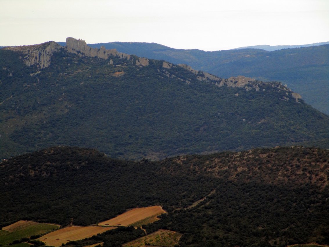
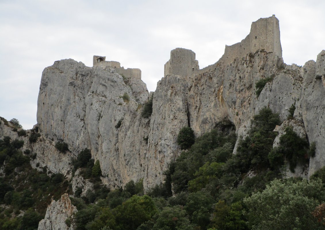
The castle, the highest point of which is some 2,600' above sea level,
belongs to at least 4 distinct building phases. It occupies a
craggy summit some 1,000' long by up to 300' wide which dips at about
30 degrees from south to north. The fortress is then split into 3
wards. To the east is the lower ward which may contain some of
the oldest buildings. To the west of this, occupying the centre
of the castle is the large, but poorly defended middle ward. This
is overlooked by the highest part of the castle, the upper ward to the
west. The nature of the landscape, with a deep crag to the north
and more sloping ground to the north, means that the defences tend to
cluster towards the north. Peyrepertuse is a truly massive
castle, which seen from the distance of Queribus looks more like a rocky crag, than a castle.
The inner part of the lower ward contains the oldest part of the
fortress. This exists within the main triangular lower ward,
which has a spur shaped tower to the east and an inner ward or donjon
cluster containing a keep, a logis and church to the SW. In the
north wall of the lower ward is a much rebuilt hole in the wall
entrance to the NW, protected by a barbican, like at so many
‘Cathar' castles, viz. Aguilar, Cabaret, Quertinheux, Roquefixade, Surdespine and Termes.
Between the spur to the east and the gate to the west are 2 open backed
D shaped towers roughly equidistantly placed. A somewhat similar
arrangement is used in the east wall at Termes.
The wall and the towers are of a similar rubble construction and have
simple crossbow loops with fish tail oillets. These are at ground
floor level. Excavation inside the NW tower showed evidence that
the wall had been built in the 1240s over the site of the earlier
village which was destroyed at this time. The village was centred
around the church of St Mary which still shows many Romanesque
features, even in its current defensive mode.
The outer ward south wall has a well hidden postern between the
garderobe turret and the logis which leads to a fissure in the rock
which could be navigated by those with great agility. Beneath the
rock, on which stands the governor's house at the southern extremity of
the inner donjon cluster, lies a series of 2 rectangular rooms along
the south enceinte. This obviously once formed a logis and has
the remains of an overhanging garderobe to the SW. Similar
structures can be found at Lastours on the keeps of Quertinheux and Tour Regine.
In the small donjon cluster to the SW is an old circular keep
overlooking the converted eleventh century church to the north and the
governor's house to the east. Externally in the church the change
between Romanesque and Capetian is clearly seen in the change from
small building blocks of the early work to the large ashlar blocks
above. Opposite the church, the keep has obviously been lowered
and was later used as a water cistern. It should be noted that
round keeps in the Pyrenees are quite unusual and the nearest tower to
this is probably Villerouge-Termenes. The keeps at Lastours seem later than this simple tower, which was perhaps most like the Moulin Tour at Chinon.
At Peyrepertuse the governor's house is placed in an elongated D shaped tower, similar to that found at nearby Durfort as well as those found in Wales like Carndochan, Castell y Bere and Ewloe.
The St George chapel and its associated tower in the upper ward at
Peyrepertuse are also of this style, although the contemporary D shaped
tower at Castelnau de Levis is
quite different in layout and style. The Peyrepertuse little
donjon complex has gates to E&W as well as a barbican protecting
the east one. This structure appears unique and is perhaps most
similar to the donjon complex at Dirleton in Scotland.
A curtain runs from the NW corner of the old church in the donjon
complex to the west end of the lower ward north curtain, with which it
forms a butt joint. It then runs a few yards beyond and joins the
middle ward curtain, becoming a part of the barbican the middle ward
curtain becomes to the east.
The upper castle is known as St George (Jordi)
after the D shaped chapel which makes up its southern section.
This is joined by 2 walls to another smaller bulbous D shaped tower
that contains a cistern and commands the middle ward below, somewhat
like a smaller version of the D shaped tower at Castelnau de Levis.
At 60 degrees to this is the north curtain of the upper castle which
runs some 200' NW to make a right angled corner back towards the summit
of the crag. The centre of the curtain on the north front is
occupied by another D shaped tower. In the building beside this
is another cistern. Coins found in excavations here ranged from
the thirteenth to the fourteenth century and probably indicates the
time of the citadel's main use. In the late sixteenth century, or
slightly later, the decayed walls were used for collecting water for
pastoral activities. The whole of this upper complex seems to be
of one build and was probably completed in the autumn of 1250.
This fits well with the shoulder headed arches of the interior and the
unusual crossbow loops which have rectangular basal oillets.
Why not join me here and at other French
castles? Information on this and other tours can be found at Scholarly
Sojourns.
Copyright©2019
Paul Martin Remfry