Tebay
Tebay is an odd castle, much mutilated by the passing of time and
the River Lune. This river flows southwards from Tebay to Kirkby Lonsdale
and then to the sea in Morecambe Bay. The site of Tebay castle
therefore blocks the main north to south route through the mountains
between Kendal and Penrith and is at the focal point between these castles and Brough, Bowes and Barnard Castle to the east. As such it may have been founded in the reign of King William Rufus (1087-1100) when this district was brought firmly under Norman control with the fortification of Carlisle in 1092. That said, as a powerful motte and bailey castle it might just be a royal fortress from the time of William I
(1066-87) marking the northernmost outpost of that monarch's Yorkshire
lands, as the lands mentioned in Domesday lie only some 5 miles to the
south of it. Most likely though, it is the work of Rufus when his forces advanced over the mountains to the south and east of Tebay.
Despite this speculation, the first known holder of Tebay was probably a Ralph Tybai
who witnessed a grant of Kirkby Thore to Holme Cultram abbey in the
period soon after it's foundation around 1150. Mention of Tebay
can next be found in the Westmorland
pipe roll of 1178. Here it was recorded that £1 worth of
land had been given to Herbert Tebay in Tebay by the king's writ.
Judging from his name, he or his family had previously held land here
and that tenure may have been disrupted during the Young King's War of
1173-74. Later evidence certainly points to political
interference in this castlery.
It has been speculated for a long time that the land of Tebay belonged
in the twelfth century to the Allerston family of Yorkshire who held it
as a member of Pickering. However,
the surviving evidence does not support this. Instead the early
lord of the district appears to be the above mentioned Herbert Tebay
who also oversaw the restocking of the royal Westmorland
manors in 1178. Herbert was to continue holding the 20s worth of
land in Tebay until 1200, even if the accounts recording this in Westmorland did largely stop after 1179.
It has been claimed that in 1189 Tebay passed with the heiress Helen
Allerston to Alan Valoignes (d.1195) and then to her next 2 husbands in
succession, Hugh Hastings (d.1202) and Robert Vipont (d.1228). A
study of the evidence disproves this assertion. In 1191 it was
noted that the sheriff of Westmorland
was allowed 1m (13s 4d) for the land given to Alan Valoignes for the
past half year at the king's writ. Presumably then, the king
granted Alan his land at the same time as Gilbert Fitz Remfry was
granted his lands in Kendal, although Alan's
charter seems not to have survived. The next year, 1192, the
sheriff was allowed the full 2m (£1 6s 8d) for the land which had
been given to Alan Valoignes (d.1195). This allowance of 2m
(£1 6s 8d) continued until 1195 by which time Alan was dead and
the quittance was subsequently allowed to Hugh Hastings who had fined
220m (£146 13s 4d) for having Alan's widow to wife and all his
hereditary lands. The quittance of 2m (£1 6s 8d) for the
land Hugh Hastings (d.1202) was recorded year on year until 1200.
However, this land does not appear to have been Tebay, but may possibly
have been Crossby Ravensworth (Crosseby Ravenswart),
the church of which was granted by Torphin Allerston to Whitby abbey
before 1156 and confirmed by his son Alan in September 1174. This
vill lay only 6 miles north of Tebay and also remained to the Hastings
family.
In 1200 Herbert Tebay fined for 10m (£6 13s 4d) for having his
son Robert placed in charge of his hereditary lands of which he
immediately paid 5m (£3 6s 8d). The next entry states that
Hugh Hastings (d.1202) fined for 100m (£66 13s 4d) for having the
land of Tebay as a hereditary fee. Of this sum he paid £20
that year, leaving a debt of £46 13s 4d. The fine roll adds
a little further detail to this with the statement that for having Tibbey
in hereditary Hugh was to render to the king 5s yearly for all services
owed. The implication from this small amount could well be that
Tebay was largely wasted at this time. The case for the
Allerstons holding Tebay is also demolished at Hilary 1200 when a jury
found that:
Tebay (Tibeia) was in the hand of King Henry the king's father after Hugh Moreville
took it away from Sheriff Peter in time of war, and likewise in the
time of King Richard and in the time of the king's lordship, until he
delivered it to the aforesaid Hugh [Hastings], who now holds it.
Quite clearly from this, Tebay was in the hands of the sheriff of Westmorland until the war of 1173-74 when Hugh Morville
(d.1202) seized it, probably for the king of Scots. It was then
retaken by royal forces and remained in the king's hands until 1200
when it was granted by King John
to Hugh Hastings (d.1202). Herbert Tebay can therefore been seen
as nothing more than a tenant of the lordship which was probably
originally based upon Tebay castle. This again supports the
notion that the fortress was founded by William Rufus (1087-1100), around 1092 when he annexed Carlisle.
Tebay castle then remained a royal fortress, probably until it was
destroyed or abandoned when the North of England was annexed by King David of Scotland
in 1138. Thus, up to the war of 1173-74, the castle site remained
under the nominal control of the sheriffs. Certainly no mention
of Tebay castle ever appears in the surviving historical record.
Although it can be seen that the overlordship of Tebay belonged to Hugh
Hastings in place of the sheriff/king from 1200, it is also clear that
the Tebays held Tebay from them. Robert Tebay, who took over the
land from his father in 1200, seems to have been alive up to around
1240 and had at least one house in Carlisle. This small link of Tebay with Carlisle, may strengthen the impression that Tebay castle may have been the work of William Rufus (1087-1100) during the conquest of Carlisle in 1092, rather than an earlier work of his father, William I (1066-87). Robert Tybai was still living in 1246 when he was provost of Carlisle. It is presumed that he was succeeded by a son, Simon Tybai who is mentioned in the third quarter of the thirteenth century. Thomas Tybay
may have been his son who was witnessing charters in 1270 and still
living in 1293 and later. Presumably none of these men, or their
overlords lived at Tebay castle, which was probably abandoned quite
early in its career when its position by 2 flooding rivers made it
untenable.
It can therefore be seen that the castle was probably abandoned before the site was seized by Hugh Morville
(d.1202) in 1173/74. If the castle was now worthless, the same
was not true of the land. In 1201, Herbert/Robert Tebay paid the
last 5m (£3 6s 8d) of his fine, while, after the debt of Hugh
Hastings for having Tebay is noted, came a new fine of 20m (£13
6s 8d) and a palfrey for Hugh having warren in Tebay (Tieby) and Crosby Ravensworth (Crossebi).
Of these 2 places, Hugh seems to have acquired Crossby Ravensworth from
the Allerston family, but, as we have seen, Tebay he had bought from King John.
The 2m (£1 6s 8d) that the sheriff allocated to Alan Valoignes
and then Hugh Hastings was therefore more likely for Crosby Ravensworth
than Tebay. In 1202 it was recorded that Hugh paid £6 of
his debts, bringing the total down to £80 1m (£80 13s 4d)
and a palfrey. The same year it was also noted that the sheriff
owed and paid 13s 9d from the farm of Tebay held by Hugh
Hastings. This is no doubt due to the sheriff taking control of
Tebay after Hugh's death this year before 7 November 1202. The
custody of Tebay, with the widowed Helen Allerston, then passed to the
bishop of Norwich on 14 July 1203 and in 1204 to Robert Vipont who took
on the debt assigned to the bishop of 100m (£66 13s 4d) for
custody. The same year he married the lady, thus taking Tebay
into the Vipont estates. As Robert also obtained Appleby castle as well as all Westmorland
that year, Tebay disappears from the historical record as do the pipe
rolls for the county. Indeed, when Robert does begin sending in
some accounts for the county from 1207 until 1211, Tebay never appears.
Despite the general lack of evidence, the final descent of Tebay is
clear. Sometime after 1204, when Robert Vipont obtained Tebay by
marrying the widow of Hugh Hastings (d.1202), his brother, Ivo Vipont
(d.1239), made a grant to St Peter's Hospital, York. In this the bounds of the grant were described as running along a brook to a pit (foveam) by the highway (publicam stratam) from Appleby
to Tebay and then westwards to the bounds of Crosby
Ravensworth.... One of the witnesses to this was Thomas Hastings
(d.bef.1246), the lord of Tebay. It would seem that he now held
his land of the Viponts as during the reign of Edward IV (1461-83) a
feudary of the Clifford lordship of Westmorland was made. This recorded that Thomas Hastings (d.bef.1246) once held Tibbey
directly as 2 carucates of land and paid 5s yearly to be quit of all
services. Currently it was held from an unnamed Hastings by
Thomas Wharton and Richard Ristwald. Quite clearly Tebay was
still held under the same terms as Hugh Hastings had bought it in
1202. The castle, of course, being derelict and probably half
washed away, was never mentioned.
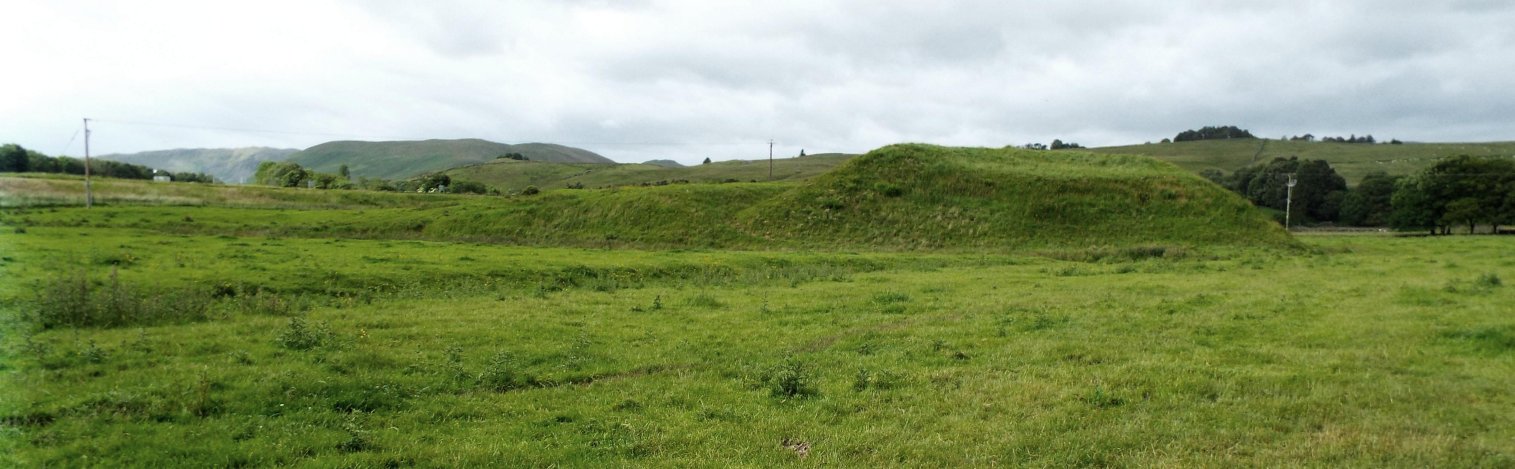
Description
The denuded remains of Tebay castle, presently known as Castle Howe,
stands some 300' east of the junction of the Birk Beck with the River
Lune which skirts around the site from the east. The castle is
built of glacial debris and as such proved easy prey to the flooding of
the river which had helped form its site. The castle consisted of
a large motte to the north. This has been largely destroyed, with
probably less than a quarter of it still remaining. The northern
portion has simply been eaten away by the floods of the River
Lune. What remains is wedge shaped, with the southern portion
still having the remains of its circular ditch dividing it from the
bailey to the south.
Judging from the remains of the motte it was probably about 180' basal
diameter and may have stood some 20' or more above the flood
plane. It may have had a summit diameter of some 80', while the
apparent rampart on the top would seem to be more a feature of the
river erosion of the base of the motte leading to its partial
collapse. This in turn would suggest that the exterior of the
motte was made of a more tamped clay than the interior. The ditch
to the south is about 20' wide and nearly 10' deep and has a slight
counterscarp to the south. There is no trace of the ditch
continuing around the motte, but due to the destruction of this portion
of the castle by erosion that is hardly surprising.
The castle bailey lay to the south of the motte and is currently at
least 300' east to west by over 350' north to south and standing up to
8' above the flood plane. The south side of the ward has
apparently been damaged by the motorway slip road and probable dumping
from its construction. Traces of a ditch remains around the
bailey and evidence of a rampart is visible here and there amongst the
destruction. An old report stated that ‘evidence of exposed
stone structures [were] visible on the eastern side', but there is now
no trace of this, though some large stones can be seen in the flood
washed western scarp of the site. If the site was a royal build,
then certainly its motte dimensions, as far as can be judged, do not show it as a great motte.
Copyright©2023
Paul Martin Remfry