Helmsley
Like at so many castles, there is no foundation date for Helmsley
castle, indeed it is not even possible to say which family founded the
fortress. Its initial style appears eleventh century, but the
only source to mention the building of the castle attributes it to
Robert Roos who died in 1226, yet the castle may have been mentioned as
early as 1141. To make sense of the history of the site a study
will be made of the lords who owned Helmsley manor from 1066
onwards.
After the Norman Conquest, when Helmsley was held by 3 unnamed English thanes, William the Conqueror
seized the land with its church and priest and subinfeudated it to his
cousin, Count Robert of Mortain (d.1090). Count Robert was
apparently responsible for founding Berkhamsted and Launceston castles, both motte and baileys. He also had control of the Roman fort at Pevensey in which he had a castle. At this time the manor of Elmeslac
was recorded as being worth 10s and consisting of 6 villagers, a priest
and a church. In 1066 it had been worth £1 12s.
Obviously it had suffered in the 1069 Harrying of the North. The
name Helmsley was also sometimes written as Hamelak in the Middle Ages.
Count Robert's son, William, was disinherited in 1103 and it seems likely that King Henry I (d.1135), afterwards granted Helmsley and other royal domains, including Wark
in Northumberland, to William Espec, or his son, Walter before
1126. It is presumed that Walter built the castle, probably
before the battle of the Standard in 1138 in which he was a principal leader. After this, William Aubigny of Arundel and New Buckenham castles, was made earl of Lincoln, an event that helped lead to war in 1140. With the coming of the Empress in 1139 troubled wracked King Stephen's realm. During 1140 Earl Ranulf of Chester (d.1153) rebelled over the ownership of Carlisle and Cumberland
and occupied all the garrisons of Lincolnshire. Due to the
geographic positioning of their lands, the young Count Alan of Richmond (d.1146), was hostile to Earl Ranulf. This led to warfare between them as Alan remained loyal to King Stephen
(1135-54). As troubles multiplied in the North, Count Alan took
it into his own hands to attack those he regarded as enemies.
Consequently he:
furtively climbed the walls with his men by night attacked rushing Galclint castle taking the castle itself with a large amount of money, while ejecting William Aubigny with his men.
Aubigny was most likely King Stephen's new earl of Lincoln
and such an attack on him would suggest that Alan disliked his
promotion. Alternatively the Aubigny mentioned might have been
William Aubigny Brito, the lord of Belvoir castle. Simultaneously
Earl Ranulf was waging his own war against Lincoln that eventually would lead to the battle of Lincoln in 1141 and Earl William being transferred to the earldom of Sussex which he ruled from his castle at Arundel. Much has been written about the mysterious castle of Galclint,
but it has been suggested that it was a corruption of the placename
Gelling - and Gelling East lies just 4 miles south of Helmsley
castle. Certainly it is a possibility that Earl Alan seized
Helmsley castle as part of a movement against Earl William
Aubigny. That said, why William's men should have been in
Helmsley is unknown and Alan and William were later to both fight for King Stephen at Lincoln on 2 February 1141. That battle proved a disaster, with Alan being captured by Earl Ranulf of Chester who:
compelled him to marry his niece... and resign to him [Ranulf], Galdint castle and the treasure he had found in it after he was starved and molested in other ways.
Ranulf did not have matters his own way and in the sea-saw battles that
shook the North for the next few years obviously lost control of
‘Galdint' castle again. At the end of the day any
identification of this castle is problematical, but the advantage
Helmsley castle has over the other sites put forward for this treasure
filled castle, is that there is actually a castle at Helmsley, unlike
the other sites suggested, viz. Aa part of the defences of Lincoln, Gilling in Ryedale [aka Gilling East], Gaultney Wood and Gildersdale.
By the end of the Anarchy in 1154 Helmsley was certainly back under the
control of Walter Espec if it had ever left it. Walter had no
children and he resigned from this world by joining Rievaulx abbey in
the period 1150 to 1155, apparently allowing his lands to escheat to
the Crown. Consequently by September 1158, his lands had been
distributed by King Henry II
(1154-89) to Robert Roos (d.1163). This is somewhat unusual as
normally the bulk of any escheated estates would have been passed to
the elder heir or heiress, which in this case would have been Hawise
Espec, the wife of William Bussey. Possibly this did not happen
as William had recently died. It would appear to have been as a
consequence of the grant to Roos that, William Buissey the son of
William and Hawise, was forced to proffer the king 100m (£66 13s
4d) in Buckingham and Bedfordshire by September 1158, to have a fair
partition of the lands of Walter Espec with Robert Roos.
Similarly Geoffrey Trailey, the son and heir of the third sister,
Albreda Espec, also offered 100m (£66 13s 4d) for the same
purpose. How they faired against Robert is not recorded, but that
year Robert was charged with inspecting the castle building work at Scarborough castle
a job he seems to have continued until 1161. This was important
and trustworthy work for the Crown. Also in 1158 it was recorded
that Robert owed the Crown 1,000m (£666 13s 4d) for the lands of
Walter Espec. Of this he immediately paid 100m (£66 13s
4d). Almost certainly this was for having the bulk of the Espec
estates and especially Helmsley castle. As the amounts owed by
Buissey and Trailey were paid off by 1160 it is to presumed that the
lands they received were in the South. Meanwhile Robert's great
debt recorded at £533 6s 8d was respited until the king should
return to England. This state of affairs continued until Robert's
death in 1163.
Although not yet mentioned as a castle, unless as the enigmatic Galclint, Helmsley and Wark
castles are alleged to have been ‘raised' by Robert Roos (d.1226)
in a Rievaulx document - It is truly said that Robert Furan [Roos]
raised the castles of Helmsley and Wark.
However, this document was written in or after 1513, so its relevance
to thirteenth century castle building is negligible, especially as
documentary evidence show that Wark castle was
at least 100 years older than this. Regardless of the near
uselessness of the source, this ‘evidence' has been claimed to
prove that Robert built all the original masonry at the castle on an
older ringwork.
Robert was of some importance for he married an illegitimate daughter
of King William the Lion (d.1214) in 1191 when he came of age.
She was the widow of Robert Bruce of Lochmaben who had died the same year. In 1215 Robert joined the Northerners in their opposition to King John
and was one of the 25 barons chosen to ensure the king's compliance
with Magna Carta. This resulted in the seizure of his lands and
the capture of his son and heir, William (d.1264), at the battle of Lincoln
in May 1217. However there is no evidence that he lost Helmsley
castle. After Prince Louis left the country, father and son made their
peace with the new government of Henry III
(1216-72). One of Robert's last acts was witnessing the reissue
of Magna Carta in 1225. He died on 23 December 1226 as a Templar
and was buried in the New Temple in London, after having divided his
inheritance, his eldest son William being given the barony of Helmsley,
while his younger son got Wark. A chapel
was consecrated at the castle in 1246 at the bidding of Robert's son,
William Roos (d.1264). It is to be presumed that Helmsley castle
was largely complete by this point, although the raising in height of
the keep could have been fourteenth century.
Helmsley remained a military backwater during the rest of the
thirteenth century, although the fortress must have been reasonably
maintained as in 1334 it entertained King Edward III
(1327-77) on 31 May while Edward visited the northern castles of his
realm after his victory over the Scots at Halidon Hill in 1333.
With the eclipse of the Lancastrian Roos family Helmsley castle was
given to the future Richard III (d.1485) in 1478, but was restored on
his downfall to Edmund Roos. The fortress was held for the
Royalists during the Civil War and, after its surrender to the
Parliamentary forces of 700 foot and 300 horse in November 1644, was
subsequently slighted. The residential part of the castle was
again rebuilt, but abandoned again before the century was out.
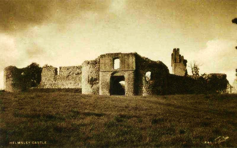
Description
Although heavily defended with earthworks and masonry, Helmsley castle
was not situated in a strategic position, indeed, like nearby Pickering castle,
it lies in rather a backwater and so the 2 have rather disappointing
military histories. Helmsley undoubtedly owes its foundation to
its location as a convenient centre of firstly the Espec and later the
Roos baronies. The castle lies on low ground just north of the
diminutive River Rye on the west side of Helmsley town. It is
often described as a ringwork, but it is a rectangular platform about
350' north to south by 220' east to west surrounded by a deep 70' wide
ditch which in turn is surrounded by a counterscarp and then an outer
ditch. Presumably the platform was the first castle dating back
to Walter if not William Espec's time in the early twelfth
century. However it is not impossible that the first
fortification of the site was undertaken by the counts of Mortain in
the late eleventh century. It is also possible that the deep ditching dates to the reign of King John when similar works seem to have been undertaken at such castles as Berkhamsted, Buckenham and Castle Rising.
The Inner Ward
The ward platform is an odd shape, the masonry enceinte formed of 2
distinct rectangles. That to the north is about 170' deep and
200' across. The smaller southern rectangle is about 100' deep
and 130' across. The masonry curtain around this enceinte appears
of one build and the difference in depth occurs at the point of the
west tower, set opposite the keep to the east. Here the south
wall of the west tower projects down the scarp almost to the ditch
bottom and runs northwards to the north-west tower at the apex of the
site. Possibly this was due to the shape of the rock at the time
of construction or more likely it marks a slight extension of the site
to the north-west. Certainly the north-west wall is built upon a
rocky crag which continues on the south side of the west tower, but has
a rampart on top of it. It would therefore appear that the
northern section from the west tower and including the later mansion is
a later insertion built down from the base of the rampart and occupying
the site of the scarp which was then filled up to make a new ground
level. If this is correct the masonry of the enceinte here should
be different to that to the south of the west tower and although it
doesn't appear to be, the style of the north-west tower does seem
different to its 4 compatriots, while the curtain itself appears
slightly thinner. The north-west tower is about 30' in external
diameter, while the north corner tower is more like 28' and the north
gatehouse towers are about 26'. Further, the south corner tower
is only about 22' in diameter, while all the tower interiors are
equally different - the north-west tower being rectangular, the north
tower
hexagonal, the south tower an elongated D shape with a deep basement
entered via a flight of steps and a Romanesque doorway, while the north
gatetowers being D shaped and trapezoid respectively. Further,
the south tower looks like a possible addition to the wall to add
flanking at a vulnerable corner. If it is such it rather
resembles similar towers at Berkhamsted and Richards Castle.
Presumably the original entrance to the castle was to the south-east where the shattered remains of a rectangular gatetower
still stand at a slightly rakish angle to the main curtain. The
tower is awkwardly set against the north curtain wall. The
gatetower was about 32' square including its pilaster buttresses to the
south, flanking the gate. The first gate was defended by a
portcullis before the gate protecting the vaulted chamber within which was about 14' deep and 18'
across. At a later date a rectangular barbican was built jutting
out some 30' from the tower into the ditch where a pit marks the site
of a drawbridge used to cross the gap to the counterscarp. Later a large
barbican was constructed on the wide counterscarp. Various buildings lay
along the 3 sides of the rectangular curtain of the smaller southern
portion of the ward. That this section was a different building
phase to the northern section is again suggest by the fact that the
curtain is slightly thinner than its northern counterpart. The
remaining doorway into the first floor of the keep would suggest the original wallwalk was
at a low 15' above internal ground level, which may again suggest an
early build date, or at least not a great concern for safety with such
a low curtain height. The lack of stairs in the small enceinte
towers would suggest that access to the curtain wallwalk was original
gained via steps along the inside of the wall. Traces of 2 of
these exist along the curtain between the keep and the south
gatetower. Between the gatehouse and the west tower lay a
kitchen, pantry, buttery and an impressively large great hall, all now
largely reduced to foundations.
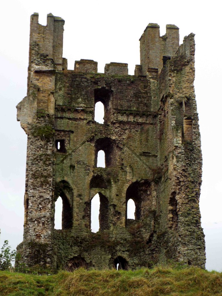
The Keep
It is possible that the keep is the oldest structure on the site, even
if its remains have been much altered. The eastern half of the
structure is quite down to the foundations, although great chucks of
the fallen masonry still populate the ditch. The tower stands off
centre along the north wall of the enceinte and is not set at right
angles to it. This would again suggest a different phase for
their constructions. Only the 100' high south-west wall of the
tower remains intact and this suggests a total of 3 builds.
Initially there was a single storey structure, apparently with a
spiral stair in the north-west corner leading to the summit, or maybe a
second floor which is now destroyed. This chamber can be seen
externally in the wall as it has a slightly different build to the 2
floors above. This is best seen in the external basement west
wall. The first 15' of facing here consists of irregularly laid
blocks of local grey stone. Just beneath the sills of the windows
of the next floor the stones become more regularly laid and slightly
smaller. Internally there is an offset, partially disguised by
the collapsed, later stone vaulting.
The 2 surviving basement loops to the west are set at different levels,
while there was apparently a third in the vice. To the north was
a slight pilaster buttress which also ends at first floor level with 2
chamfered courses. Immediately east of this, in an uncomfortable
position half way up the floor and too tight to the buttress, is an
early English pointed doorway, which has later been blocked and
converted into a loop. Another doorway slightly above this level
fed onto the destroyed curtain wallwalk. At the end of the north
face of the keep was what appears to be a sallyport leading onto the
berm. Beyond this the semi-circular face of the tower is down.
On the south side of the tower an Early English doorway has been
punched through the wall to give access to the basement. Above
and east of this is the doorway which must have led to the wallwalk.
It would appear to have been approached by a straight stair
running alongside the curtain.
Above the masonry change at the top of the basement are 2 further storeys rising another 50'. These
2 storeys originally formed the main floor of the second build.
This now has 3 different
windows to the west. These have slightly pointed arches, which
would appear to
be insertions, although the northern 2 may have had tall, Romanesque
embrasures within. Centrally, above these, was a large Romanesque
arched window of 2
orders. This window was set high in the crease of the original
second phase roof gable. Presumably this was made into a new
floor level when the final upper storey and garrets were added.
The main masonry of the tower, above the basement, consists of roughly
coursed blocks with thin slithers of laid stone used for levelling up
at irregular intervals, while the quoins and fenestration are made of a
yellow
sandstone. The
pitched roof hidden behind high walls seems common in northern keeps
and can be seen elsewhere at Appleby, Peak and Prudhoe where again the roof has been removed and upper floors added.
At the summit of the keep is a laterstorey
with 2 attractive garrets
projecting slightly at the angles. This consists of larger blocks
of masonry than the 2 builds below. The battlements would appear
to be of a later date again. It should be noted that the nicked
corner quoins run from the basement to the summit of the keep and
therefore probably belong to the final phase of the tower's rebuilding.
Outside of Wales D shaped keeps like
Helmsley are uncommon and it is possible that the original tower was
rectangular and was later converted to D shaped to make the tower's
exposed face stronger. Another unusual feature is the spiral
staircase in
the centre of the north wall at the higher levels of the keep.
Usually vices are placed in the
corner of a tower which offers more room for their structure. The
only other
aberrant example like this is at Scarborough keep
and it should be noted that Robert Roos (d.1163) was tasked with
viewing the works in that keep. However, the Helmsley vice would seem to
be more related to the alleged fourteenth century work at the site. Whether
this vice is significant to Robert Roos (d.1163) or whether this was simply the
way a local mason liked to build keeps is unknown and unknowable.
What is not surprising is that the weak point of this vice is where the
keep collapsed on this side. The same is true of Scarborough castle keep where the vice wall has totally disappeared.
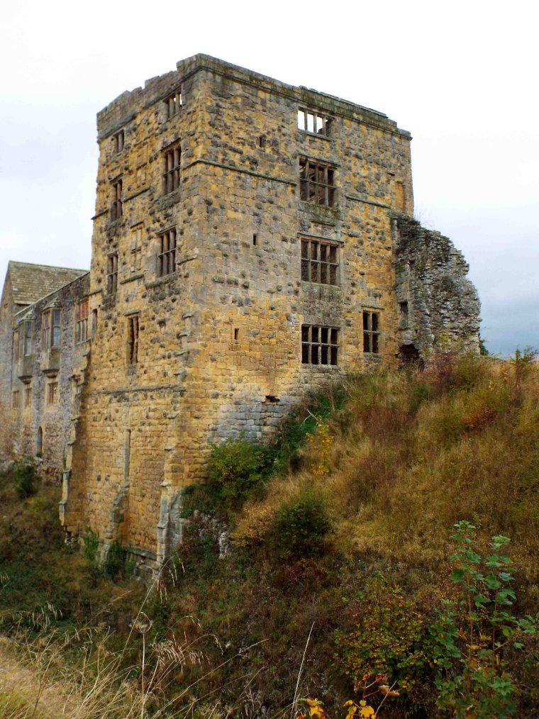 The West Tower and Associated Buildings
Roughly opposite the keep was the approximately 35' square west tower
which projected strongly down the scarp. This tower has been
massively rebuilt, if it is an original structure, and has a fine late
plinth riding down the scarp to a buttressed base. The tower
contains 4 Tudor floors over a basement, the top storey being attic
rooms for the servants. The basement and ground floor may be
original and
seems well meshed to the curtain at the base, but the upper doorway
looks
pseudo-Romanesque. The deep entrance to the basement suggests
that the site may have been raised dramatically, although this
basement, that of the south tower and the keep would suggest an uneven
raising. It has also been suggested that this represents an early
ditch dividing the northern and southern rectangles of the ward.
Much rebuilding has gone in this tower, while the 2 uppermost storeys
are made of much later ashlar. The junction with the remaining
fragment of curtain wall, including the blocking
of a north doorway and the provision of a garderobe in the curtain,
blocked by the apparently earlier hall block, make this section of wall
difficult to decipher. Internally the shoulder headed doorways
suggest early fourteenth century refurbishment.
North of the tower is the later 75' by 20'
manor house and the foundations of many buildings. Nearer the
keep are traces of a 74' by 28' building. Considering its east to
west orientation it seems likely that this was chapel consecrated in
1246. Unfortunately, only a small part of its south angle remains
above ground. The building was apparently converted into a
kitchen after the reformation and linked to the manor buildings by a
covered passageway.
The North Front
Beyond the manor house is a curtain leading to the north-west tower
which has a powerful plinth. A curtain wall ran from the
north-west tower to the north tower at the northern apex of the
site. Midway along this was the north gate. This was a twin
D towered gatehouse, which is now
reduced to its foundations. However, its exterior was made from a
fine ashlar, while the entrance was protected by a portcullis and
probably a drawbridge. Over the ditch was another, larger twin towered gatehouse,
set on the counterscarp forming a north barbican. At the far end of the north front was
another boldly projecting corner tower. From here another
much rebuilt curtain, pierced by 3 loops to light the buildings that stood alongside it, ran back to the keep.
South Barbican
The south barbican was a powerful structure, possibly designed to make
up for the weak defence of the early rectangular gatetower. The barbican
consisted of a rectangular enclosure running across the inner ditch and
along the counterscarp to make a small fortified ward. This had D
shaped towers to the north, east and south. Centrally in the
south wall was another twin D towered gatehouse
which was modified in the sixteenth century. The rest of the
structure would appear to be of 2 phases, with the south wall, open
backed gatehouse and 2 flanking turrets all being the earlier work,
while the 2 ditch crosswalls and the flanking north turret would appear
to be slightly later. The design is most unusual, possibly the
nearest to this in concept are the late twelfth century north and south (destroyed)
barbicans of the inner ward at Dover.
Outer Wards
There were once outer baileys protecting both the north and south
barbicans. That to the north is now largely lost and partially
under the car park, but one bank of this can still be made out, over
250' long. Another bailey lay to the south making a ditched
rectangular enclosure running to the River Rye some 250' away.
Why not join me here and at other Northern
English castles this year? Please see the information on this and
similar tours at Scholarly Sojourns.
Copyright©2021
Paul Martin Remfry