Burton in Lonsdale
The fortress, just north of the River Greta, would have commanded the route from Hornby and thereby Lancaster, to Ingleton and thereby to Skipton.
Despite its positioning on a major routeway and being a centre of
Mowbray lordship, the history of Burton castle is generally built up of
hearsay. To cut this away the following will list the recorded
original documentation about the castle, which will be followed by some
speculation.
Just before the Norman Conquest, Burton (Bortaine)
was part of the manor of Whittington vill in the Lune valley.
This had been owned by Tostig, the younger brother of King Harold and
had been and apparently was waste. Tostig was slain at the Battle
of Stamford Bridge, although the site had presumably passed to his
elder brother on Tostig's exile. After the death of King Harold, King William I (1066-87) would seem to have continued to hold Burton until some point after Domesday in 1086 when either he, or his son, King William Rufus
(1087-1100), appears to have granted the manor and possibly the
fortress too, to Earl Robert Mowbray of Northumbria. Certainly
the manor was later found as the administrative centre for the
surrounding Mowbray estates in Yorkshire and Lancashire.
Meantime Earl Robert was disinherited in 1095, ending his days after a
long time in prison as a monk at St Albans abbey. Burton and
presumably its castle were resumed by the Crown on Robert's
imprisonment. At some point King Henry I
(1100-35) regranted the Mowbray lands to Robert's ex wife, Matilda
Laigle, before 1108, when she married Nigel Aubigny (d.1129). On
the death of her brother, Gilbert Laigle, in 1114, Nigel divorced
Matilda and married Gundreda Gournay in June 1118. However, King Henry I
obviously allowed Nigel to keep the Mowbray lands and they were seized
by the Crown, before 29 September 1129 when Henry I had taken control
of the lands lately held by the now obviously deceased Nigel.
Before the pipe roll was drawn up, the king had passed the lands on to
Robert Wyville and Henry Montfort and amongst the allowances made to
them was £21 5s 10d for the force kept in Burton in Lonsdale
castle. This consisted of 1 knight, 10 serjeants, a porter and a
watchman. Mowbray's other castles were Brinklow, Kendal, Kirkby Malzeard and Thirsk.
By 1138 Nigel's only surviving son and heir, Roger, who took the
surname Mowbray, had inherited all his father's lands. Roger then
fought in the battles of the Standard (1138) and Lincoln (1141), before
joining in the second Crusade in 1148. It was possibly at this
time that he granted Lonsdale, Kendal
and
Horton to William Fitz Gilbert Lancaster (d.1170). Certainly that
was thought by the time of Kirkby's Inquest in the reign of Edward I
(1272-1307) when it was found that the lands in question were Sedbergh,
Garsdale, Dent, Thornton in Lonsdale, Burton in Lonsdale, Bentham,
Clapham with Newby, Austwick, Lawkland and Horton in Ribblesdale.
Burton castle therefore seems to have
been held as the 2 fees owed by William to Roger Mowbray in 1166.
Presumably the castle remained in Mowbray hands, or reverted to them on
the death of the last William Lancaster in 1184.
A little before 21 November 1297, King Edward I took control of the manor of Burton in Lonsdale on the death of Roger
Mowbray. As Roger's son was only 12 at the time the manor and
presumably the castle site remained with the king for the rest of his
life; John Mowbray coming of age in 1307 and being executed by Edward IIin
1322. By the time of the death of his son in 1361, another
John Mowbray, the castle is supposed to have been abandoned as it is
not mentioned in the survey of Burton in Lonsdale. However, its
lack of mention in the vill as early as 1297 may suggest that it had
already been abandoned by this earlier date. Certainly on 3 April
1325, an inquistion post mortem found that the land of John Fitz
Matthew Burgh was 'a ruinous messuage' in Burton in Lonsdale, 'laying
waste from the devastation of the Scots'. Such devastation may
well have included the final abandonment of the castle.
Description
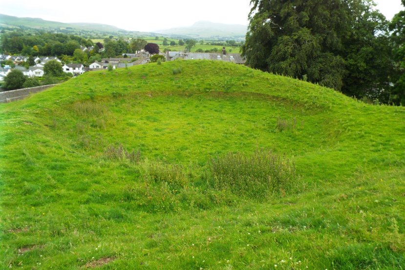
Castle Hill is an aberrant motte and bailey castle. The mound is
some 30' high and is an odd east to west oval shape, the summit being
some 110' across and 70' wide. Its height may suggest that it was
a royal foundation. Set centrally upon this odd mound are the poor remnants of what appears to have been a round tower keep
which was some 65' in diameter with walls over 5' thick. The size
of this makes it somewhat similar to the keep on the motte at Berkhamsted.
However, here the motte is an odd shape, having an east to west
orientation. This virtually proves that the motte predates the
tower and that the masonry structure is not emmotted. If this
were the case why would the soil have been piled up around the tower in
such an odd manner. The walls of the tower, assuming that it is
not a shell keep, which would have more likely followed the contours of
the motte top, are built of local rubble.
The motte ditch is best preserved to the west where it is about 10'
deep. To the east it appears to have been encroached upon by the
raised platform which leads to a farmyard. The main bailey lies
to the west and consists of a curved rectangular ward about 190' by
170' and surrounded by a ditch still up to 6' deep. A further
half moon bailey lies to the south.
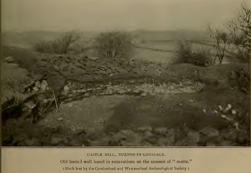
Excavations carried out in 1904 found that most finds ‘had silted
down through the soft soil to a uniform level'. This found that
at a depth of 4' under current ground level the whole site, or those
parts of it that were excavated, ie in the trenches on the motte,
baileys, ditches and banks, had all been cobbled with rough pebbles
bedded in a basis of stiff clay. On the motte top this
‘paving' formed a ‘shallow saucer-like concavity... that
sloped rapidly' up to the foundations of the keep walls although these
were several inches above the pavement. This would suggest that
the paving was laid down and the masonry afterwards, possibly when the
paving had been forgotten. Imposed on the paving was a think
layer of black ash containing pieces of charred, unworked wood together
with large amounts of fragments of animal bone, including part of a
human skull. Elsewhere on the motte possible graves were found
also with burnt material within them. Pits of 12' and 20' were
dug into the motte suggesting that it consisted of sand laid on glacial
clay and that it was then encased with a crust of clay into which
pebbles had been driven to form a protective shell. Evidence of a
lower mound, also encased with a pavement was found some 4' below the
foundations. As finds on the pavement included a perfect bone
needle and a flint arrowhead, it was presumed that the mound was
originally prehistoric and then reused as a castle motte.
Excavation also uncovered on the motte pavement were 2 coins of Henry II
(1154-89) and ‘Norman' arrowheads and knives, along with a large
key and probably civil war tobacco pipes and a coin of Charles I.
Another coin that came off the motte top was a brass coin thought to be
of Tiberius (d.37AD). The conclusion of the excavators was that
the bailey and lower banks and even the mound may have been prehistoric
and then reused as a castle by the Normans. Their thoughts on
what appears to be a keep is even more odd, dating it to the fourteenth
century and suggested that it was ‘a retaining wall', although
what it was retaining on top of a mound was not thought a relevant
subject for speculation. Similar excavations on a mound at
Arkholme found a similar pavement with burnt deposits on it at a depth
of 9'.
From the above it is suggested that the fortress began as a prehistoric
ritual site and then was made into a Norman fortress some time after
the 1060s and refortified with a great round tower, possibly in the
twelfth century. That the castle continued in use into the
fourteenth century seems somewhat unlikely judging by the 1297 survey and a lack of excavation finds.
Copyright©2021
Paul Martin Remfry