Longtown Castle
Extracted from Woolhope Archaeological Research Section Report No.64 on which Longtown Castle, 1052 to 1241 is based.
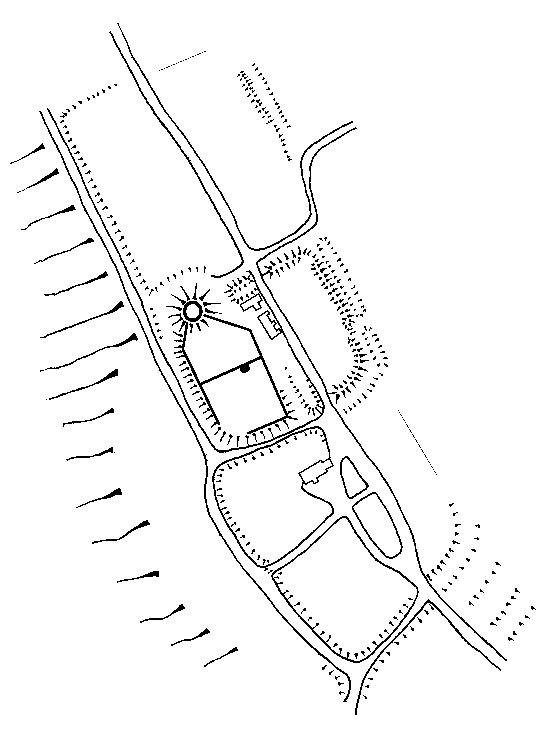
Longtown castle, a mound and bailey with outworks, stands at the south end of a spur at the north end of the village, commanding the valleys of the Monnow and one of its tributaries, which flow past either side of the castle, meeting about three miles further south. The fortifications consist of a rectangular enclosure about three acres in area, with a motte at the north-west angle, on which stood a circular keep. The outworks lie to the north of the enclosure, the ground slopes away on all sides except to the north, where it is almost level, but rises slightly. The west half of the enclosure is divided roughly into two parts of which the northern formed the inner or first bailey, and the south, second or outer bailey. The inner bailey was bounded by a curtain wall on the north-east, east and south sides, with an entrance gateway in the south wall. There appears to have been no substantial wall along the west side, where possibly the steepness of the scarp and the moat made any more formidable masonry than a light breastwork unnecessary. The general fortifications appear to be of post-Conquest date, but very possibly places on the site of and incorporating the remains of an earthwork of earlier date. It has been suggested that the site is that of a Roman camp, but, apart from the general resemblance of the plan of the quadrangular enclosure to that of a Roman earthwork, there is no evidence to support this theory. The keep and the remains of the curtain walls to the inner bailey, together with the remains of the south gateway are all of late twelfth or early thirteenth century. The circular keep is an interesting example of this somewhat unusual form of building and the unusual layout of the baileys are noteworthy.
The earthworks consist of a rectangular enclosure with rounded angles, enclosed by a high rampart and fossa, but the latter is now partly filled in on the north-west and south sides. On the west side the rampart runs into the motte, which stands at the north-west angle of the enclosure, while on the north side there is a gap between the motte and the rampart. Near the middle of the south rampart there is an inner fossa or sunk entrance running from it, and at right angles to the outer fossa. Only the southern part of the fossa remains, but it probably continued northwards across the enclosure and formed an outlet through the existing gap in the north rampart by the east side of the motte. The site of the possible north end of this fossa is now level, and forms part of the playground to the modern school buildings which have been erected there. Gaps (of more recent construction?) in the north and south ramparts afford passage for a road which runs right through the enclosure, on the west side of the south gap the bank contains the remains of masonry on the natural rocks which may be part of a former gateway; there is a small gap and path near the north-east angle. An entrance through the east rampart near the south end may be old.
The outworks are situated in a field to the north of the enclosure. They consist of a bank some 130 yards long running in a north direction from the south-east corner of the field and continuing in line with the east rampart of the castle enclosure; there are signs of a return bank at its southern extremity extending towards the west. Running almost in line with the tremendous west rampart of the inner bailey there in a low scarp, which taken in conjunction with the bank described above probably formed a large rectangular (village) fortified enclosure. In the extreme north-west corner of the field there is a slight platform or terrace about 44 yards by 37 yards and immediately south of this are some irregular slight mounds and hollows.
South of the castle, and with defences continuous with it, is a large ramparted and ditched outer enclosure, which spreads some distance down the hill to the south. Within this, immediately south of the castle fossa are remains of a wide counterscarp bank or hornwork, on the south side of which was erected a chapelry to the little borough which must have been established in this outer enclosure. The building appears to be of twelfth century date. Yet although it contains a twelfth century capitol the building was drastically restored a century ago, when practically everything of interest was destroyed. South of the chapelry (which had a burial ground) can be seen the vestiges of the market square where fairs were held until about 1906. There are traces of an old well and the cottages of some antiquity along the 'street', to the south where it passed through the earthwork defences. This is near where the present road makes its exit. With the failure of the Lacy line the borough ceased to flourish and the earthwork defences were neglected. There could never have been more than 100 burgesses.
The keep is now a breached ruin, it apparently was of two storeys only, the walls are of shaly sandstone rubble, with ashlar dressings. It is of late twelfth or early thirteenth century date, but the windows appear to have been altered at a later date, probably in the fourteenth century. It was circular in plan. Externally it had a plinth with a chamfered top, set back on a wide berm from the edge of the summit of the original motte. Above the second floor the wall face is set back with a chamfered capping to the lower part. The outer circumference is divided into equal parts by three nearly semi-circular projections; the easternmost of these projections was utilized as a chimney flue and the next southerly had a ris, of which a portion of the western part remains; the rest of this projection is now destroyed, with about eight feet of the walling at this point, for the whole height of the tower. The upper part of the walling, from a few feet, above the second storey level has all gone, as has also a part of the walling below this level on the north-east side, while the whole of the facing of the plinth or batter has disappeared. The ground floor hasp in each bay the remains of a square headed window with internal and external segmental relieving arches of ashlar and internally splayed reveals with a square rectangular recess in one of the splays of each window; all have been badly defaced; of the jamb, of the westernmost window only one or two fragments remain; of the northernmost window two of the jamb stones and one in the head remains while the external relieving arch consists of late twelfth century dressed stones enriched with carved rosettes or roundels and the soffit of one of the voussoirs, which is exposed is similarly carved. On the east side of the gap where the walling has been destroyed is a small portion of a splayed reveal, probably part of the entrance doorway. The ground floor had a timber ceiling supported on a main crossbeam with struts; the struts rested on stone corbels which remain; there are set-backs at the floor levels. On the first floor the west bay has two and the north bay one small window with chamfered jambs and square heads with segmental researches and the south-east bay has the remains of a similar window. South of and against the north-west projection is the outlet from a garderobe corbelled out from the wall on two stepped corbels at the first floor level; the front and side walls of the garderobe are carried up for a few feet vertically and the projection is roofed with a stone lean-to capping of dressed masonry. Cutting through the chamfered to the upper set-back in the walls are seven small square openings more or less regularly placed. By the gap where the wall has gone some of the steps from the first to the second floor, and the curved inner face of the rise may be seen. Behind the projection on the ground floor, the gathering for the flue remains, although the actual fireplace recess is practically destroyed. On the first floor a passage in the wall leads to the remains of the garderobe.
The curtain wall runs south-east from immediately south of the easternmost bastion of the keep for a distance of nearly forty yards; from here it ran south for thirty yards and returned at right angles till it met the west rampart, thus bounding the irregularly shaped inner bailey on three of its sides. On the north and east sides three portions of this wall approx six feet thick remaining the most easterly of which rises for some distance up the side of the motte and formerly joined up to the keep where a recess in the plinth indicates the junction. On the south side the wall is continuous from the east angle to about ten yards from the west rampart and stands to an average height of eleven feet or thereabout; but the inner face of the wall for the whole length has been destroyed. At the east end about five yards of the return wall remains. In the wall towards the east end is the entrance, it consists of a semi-circular arched opening, with a pointed forearch with groves at the side for a portcullis; flanking the opening and projecting into the second bailey are semi-circular bastions; the outer face of the westernmost bastion has been destroyed; there is a modern pent-roof between the bastions and the archway. In the angle against the east bastion is a modern stable.
The outer face of the curtain wall has a low batter surmounted by a string course of square section. This is only apparent in the straight southern section of the wall, on either side of the gateway. The wall which bounded the west side of the inner or first bailey and surrounded the second bailey, may only have been a slight breast work, but traces of the foundations approx 8' thick at the foot of the motte rather belie this suggestion.
In the second bailey, immediately south-east of the more easterly bastion of the gateway to the inner bailey, are some exposed foundations of a small building, the east end of which is formed by part of a wall approx six feet high which also acts as a retaining wall to the outer bailey. These remains, with perhaps the exception of the retaining wall, appear to be of considerably later date than the other remains. There is a low (modern?) retaining wall along the top of the scarp for the greater part of the south and west sides of the outer bailey.
The stronghold seems to have been founded by the Lacys, the Norman lords of Ewias, shortly after the Conquest. The Lacys seem to have been amongst the earliest of adventurers to gain hold upon Welsh lands and encroached upon more later, taking a leading part in the English conquest of Ireland. They gave much land to Llanthony Priory, both from their Welsh Possessions and in Ireland. The castle is said to have successfully withstood a siege in 1146, by the combined forces of Cadell, Maredudd and Rhys the sons of Gruffydd ap Rhys, but the existing masonry and fabric seems of a rather later date. After the failure of the Lacy line it subsequently became the property of the earls of Abergavenny.
Richard Kay 12/4/52
Longtown and Pont Hendre Castles
After such a comprehensive coverage of Longtown castle by Richard Kay there is little else to be said of the site without substantial further research. During the examination of the castle one or two relevant points about the construction of the fortress were raised. Firstly the composition of the motte was discussed, it being noted that such a powerful round tower as the keep would surely have collapsed if built on a man-made mound. It therefore seemed likely that the keep was built either upon a natural rock outcrop or the original ground level. This would again suggest an 'emmotted' tower, rather than a tower on a motte. Discussion of this point at a later date with Archaeologist Ron Shoesmith, however, revealed that during the excavations here in the 1970s the keep was in fact built upon a single slanting rubble foundation, somewhat like a single course of a herringbone wall. Such practice was apparently common for the foundations of heavy buildings on insecure ground. It is therefore all the more remarkable that this fine keep is still standing in such a precarious position. This also suggests that the building is significantly younger than the motte which must have had some considerable time to settle to a hardness to allow the construction of such a heavy tower. It was also noted on the day that the toothing of the south-east curtain could still be seen on the keep wall, but such a trace was not forthcoming to the south-west. It was also questioned which was earlier, the keep, or its associated bailey wall.
Further questions were also raised in the bailey where it was pointed out that the one surviving gateway separating the two baileys had a rather low and very narrow passageway for a main gatehouse. The break in the wall just N of this where the curtain turns towards the keep may well mark the site of another entrance. Certainly the curtains on either side of this breach seem to be out of alignment with one another. It has also always been asserted that the main entrance to the castle was where access is currently gained from the rectangular earthwork enclosure. However, recent excavations by R.A. Hartley are said to have uncovered a gateway to the south, which would have allowed direct access to the village ward and church. An eastern gateway, if one existed, may therefore be very late.
Running south from the castle down the slope towards the wetter lower ground is the main road from Longtown to Pontrillas. It was along this road that the 'Longtown' grew up, probably after the 1170's. On the east side of this road and to the south of the town defences are several building platforms, currently being redeveloped. After this the road fords the little stream at Pont Hendre where a castle motte stands proudly guarding its western side.
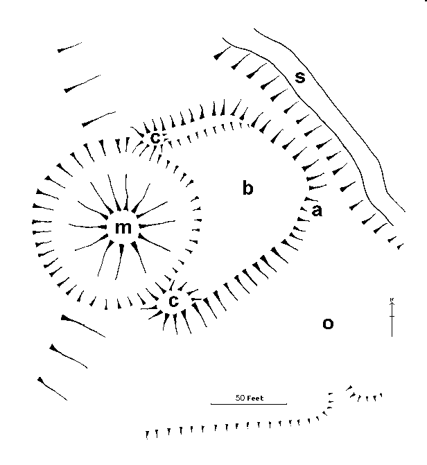 Pont
Hendre castle consists of a very steep sided motte (m) at the end of an eastward
running ridge. Surrounding it is a circular ditch, some thirty feet deep to the
west and about eight feet to the east. On this eastern side is also to be found
the kidney shaped bailey (b). This has a 6-8' rampart on its northern side
and a lesser mound to the south which was interpreted as a cavalier (c),
probably associated with the entrance to the motte. An eastward running ditch
cuts through the bailey from the motte ditch, which it was undoubtedly cut to
drain some time after the site was turned over to agricultural use. A further
ill-defined bailey to the east (o) has been postulated by Richard Kay. A
thorough examination of the site revealed no loose stone on the surface and no
indications of any masonry, though the steepness of the motte sides strongly
suggest that it contains a stone [masonry?] interior.
Pont
Hendre castle consists of a very steep sided motte (m) at the end of an eastward
running ridge. Surrounding it is a circular ditch, some thirty feet deep to the
west and about eight feet to the east. On this eastern side is also to be found
the kidney shaped bailey (b). This has a 6-8' rampart on its northern side
and a lesser mound to the south which was interpreted as a cavalier (c),
probably associated with the entrance to the motte. An eastward running ditch
cuts through the bailey from the motte ditch, which it was undoubtedly cut to
drain some time after the site was turned over to agricultural use. A further
ill-defined bailey to the east (o) has been postulated by Richard Kay. A
thorough examination of the site revealed no loose stone on the surface and no
indications of any masonry, though the steepness of the motte sides strongly
suggest that it contains a stone [masonry?] interior.
Pont Hendre has always been regarded as the predecessor of Longtown castle and may date to before Domesday, where it was recorded that Roger Lacy held the land of Ewias that was distinct from Ewias Harold which he also held. This land was later to be known as Ewias Lacy and the Domesday reference may suggest the existence of an early castle to control this district. The castle was probably of some antiquity by 1187 when it was first specifically mentioned.
In the 1170s the Welsh of the Middle March became increasingly aggressive with the powerful support of Prince Rhys ap Gruffydd of Deheubarth. In the early 1180s they took the castles of Abergavenny and Radnor, both of which had been in undisturbed Norman occupation for nearly a century. It was this eastward movement by the Welsh that caused King Henry II to refortify, or have refortified, several castles along the threatened border. It would seem likely that one of these castles fortified in this period was Longtown. In 1186 Hugh Lacy was killed in Ireland and for three years his estates were held by the Crown before reverting to Hugh's son, Walter Lacy in June 1189. It may be that the story of Rhys ap Gruffydd besieging the castle in 1146 is a folk memory of an attack on Pont Hendre in the years immediately prior to 1187, but if it is then the attack certainly did not occur for at least another thirty years after its traditional date and when Rhys' brothers were all dead. The castle attacked in 1146, and confused in earlier years with Longtown, is undoubtedly Llanstephan in Carmarthenshire, which was taken and then attacked unsuccessfully by the Normans later that year. The first mention of Longtown castle is consequently in 1187 when in the Pipe Roll £37 was expended on the garrisoning and custody of Castelli de Ewias et Novi Castelli. The castle of Ewias would seem to be Pont Hendre, whilst the 'New Castle' can be strongly associated with Longtown, the vill surrounding which was obviously founded at the same time and initially was known as Newtown (Nova Villa). By 1540 the name Newtown had mutated to Longa Villa or Longton of Ewys. In the Pipe Roll of 1188 a virtually identical entry exists. That no work was undertaken at either castle would suggest that both were defensible in 1186 when Hugh Lacy was killed. If Longtown castle is therefore a virgin foundation of the mid 1180s and the keep is founded on terra firma as the evidence seems to suggest it may therefore be that this keep is an early great tower and therefore a culmination of the Orford type donjon of the 1160s. Traditionally Longtown keep is ascribed to the 1240's, but like all such masonry structures accurate dating is well nigh impossible.
On 13 June 1995 Richard Willmott, Bob Fletcher and I revisited Longtown and paid particular attention to the town defences, not visited on the previous expedition. The southern bank and ditch of the town was discovered and easily followed to the west, where much of the west bank and ditch still survive. More modern buildings have disturbed the eastern side of the town defences and eliminated much of the rectangular enclosure north of the keep, although the eastern defences of this do still exist in a heavily denuded form just west of the Quaker Chapel at SO.322.292. The rectangular enclosure east of the masonry castle was also examined. The 'stonework' thought to be the remains of a twin towered gate tower as shown on the English Heritage display panels was thoroughly examined and could not be seen to be anything other than natural rock exposed by the cutting of the road through the site. This modern metalled road, it was also thought, was comparatively modern, the original road more likely having run along the inner ward ditch to the west of the current road. The relative strength of this earthwork in relation to the castle was also discussed and a general agreement was reached that this probably pre-dated the masonry fortress. Therefore it seemed expedient to accept the traditional association of this site with the burgh said to have been built in Ewias by Earl Harold in the 1055/6.
Paul Martin Remfry 22 June 1995
Order Longtown Castle, 1052 to 1241 which was based on these notes through the PayPal basket below.
The Castles of Ewias
Lacy, 1048 to 1403 completes the history of Longtown barony and describes
the castles and churches of the district and can be ordered through the PayPal
basket below.
Recent Work at Longtown
Excavations undertaken at Longtown in 2016/17 have significantly improved the understanding of the castle. Firstly, flint waste has shown that prehistoric tools were worked in the vicinity. Further, the find of a first century AD Colchester type cloak pin in a field adjoining the castle, plus early Carbon fourteen dates for the turf bank and the finding of first century AD pottery within it, confirm this to be a short lived early Roman fort, probably dating to the time of the conquest of the Silures. It was a similar size to those at Caerhun, Gellygaer and Pen Llystyn. At a later date the Roman rampart was raised to the current defences, some 15' high and 40' wide. This required the movement of some 30,000 cubic feet of material and yet the builders left no archaeological signature. Again this points to the army of Earl Harold in 1055/6.
A resurvey of Longtown keep also noticed that rather than the enigmatic voussoirs of one of the windows being reused, they were in fact virgin, one of them being unfinished. They would therefore appear to have been pushed into use for military purposes, rather than the probably ecclesiastical purpose they were designed for. The conclusion of the survey was that the round keep dated to the mid twelfth century soon after the fighting of the Anarchy rather than to the mid thirteenth century when the castle would have been rather a backwater.
Excavation also revealed that Pont Hendre was an unfinished castle and therefore may predate the building of the Lacy Longtown castle, the excavators tending towards this castle having been built soon after the Norman conquest, when the Saxon fortification of Earl Harold was still held against them, possibly by the local Welsh in alliance with disaffected Saxons.A full article is to be published in the Transactions of the Woolhope Naturalists Field Club LXVI [2018], 117-33.
The Twin Towered Gatehouse
In the centre of the curtain dividing the bailey is a twin towered gatehouse of unusual design, in so far as both towers are solid at least up to wallwalk level, the portcullis being operated from the wallwalk, if not a destroyed contstable's chamber above. Such twin towered gateshouses are not common. Various English examples survive at Beeston, Bungay, Clifford, Dover, Pembridge, St Briavels, the Tower of London and Whittington. In Wales they exist at Caerphilly, Carmarthen, Chepstow, Criccieth, Degannwy, Dinas Bran, Llanstephan, Llawhaden, Oystermouth, Powis, Rhuddlan, Tinboeth and White Castle. In Scotland they can be found at Kildrummy and Urquhart and finally elsewhere in Ireland at Carrickfergus, Castle Roche, Limerick and Roscommon.