Duffield
Excavation has proved that the site of Duffield castle
has been occupied in one form or another since the Roman era.
After the Romans the site was apparently used as a cemetery before the
castle was probably begun soon after the Norman Conquest. The
most likely builders were the Ferrers family who went on to become
earls of Derby. Excavation has found post holes under the current
keep which were interpreted as an early wooden tower, thought to have
been the work of Henry Ferrers (d.1089). At Domesday he held 114
vills in Derbyshire, 35 in Leicestershire, 20 in Berkshire, 7 each in
Oxfordshire and Staffordshire, 6 in Warwickshire, 5 in Essex, 3 each in
Hampshire, Nottinghamshire and Wiltshire, 2 each in Buckinghamshire,
Herefordshire and Lincolnshire and 1 in Gloucestershire as well as the
castle and borough of Tutbury.
Duffield was therefore the caput of Ferrers' Derbyshire estates and
would seem a more likely caput for his English lands than Tutbury,
which was obviously early chosen as the centre of his power as he built
a priory there before his death in 1089. Duffield castle remained
a member of the earl's holdings, but only appeared in the historical
record some 80 years later, although it would have played its part in
the Anarchy being only 14 miles from Nottingham, but more like twice that distance from Peak castle.
At the start of the Young King's war (1173-74), William Ferrers fortified Tutbury and Duffield (Dufelda) castles against the king. A year later on 31 July 1174 the earl was forced to surrender his 2 castles to Henry II
(1154-89). It is then alleged, apparently without the slightest
contemporary evidence, that the king ordered their destruction.
Despite this modern claim, the castle obviously continued in use into
the thirteenth century when it was surrendered again with the fall of
Earl Robert Ferrers in 1266. It was probably amongst all those
unnamed Ferrers castles which were ordered to be intendant upon William
Bagod after Ferrers' capture after the battle of Chesterfield. It
would seem that during the Barons War (1263-66) Earl Robert had drawn
up an instrument whereby he granted to Earl Gilbert Clare of Gloucester
(d.1295) the castles and honours of Tutbury, Chartley
and Duffield as well as Liverpool castle and other lands. By the
time of the death of Earl Edmund of Lancaster in 1297, who's father had
acquired Duffield on Earl Robert's forfeiture in 1266, Duffield was
merely a manor, a forest, an advowson and several parks, but no mention
was made of any castle either here or in later surveys. After the
castle's supposed demolition in 1266 excavation found that a small
medieval ‘peasant' building had been constructed on the
site. In 1401 the site was simply 1 acre of ground at the end of
the village called Castelfeld and worth just 1d in the Cowcher Honour
of Tutbury.
According to modern ‘history';
The motte and bailey was
destroyed in 1173, but in 1177-90 William de Ferrers built a stone
keep. Modifications were made after 1250 and in 1266 the castle
was demolished. (PastScape)
Obviously the history related above shows that none of this supposition
can be supported by any historical facts, although the latter statement
that the castle was demolished, with the proviso of at a date between
1266 and 1297, can be accepted.
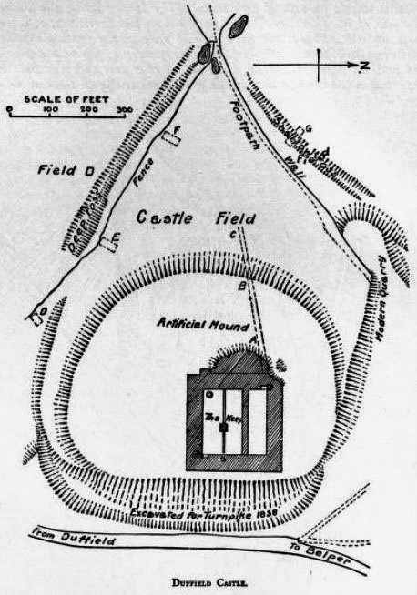
Duffield castle occupies a good position on high ground overlooking a
loop of the River Derwent some 500' to the south-west and 75'
below. The fortress consists of what was probably an irregular
sub-oval mound about 600' in diameter. Some 100' of this has been
shaved off the mound to the east when a turnpike road was built in 1838
and to the north where Avenue Road runs. This mound is too large
to be considered a 15' high motte as is often claimed. Further,
the excavation in 1886 showed that bedrock is just over 3' beneath the
current surface level of the mound just west of the great keep.
The site is therefore that of a scarped natural knoll on a ridge end
site. A large amount of Roman pottery shards were found just 2'
beneath the surface of the mound, but no trace of any masonry in a line
running west from the keep and around the summit of the mound.
There is no rampart around the ward summit and no trace of a curtain
has been uncovered by excavation. The 1957 excavation within the
keep found traces of what was interpreted as a wooden
predecessor. It was also assumed that a wooden palisade topped
the knoll to make an inner ward.
To the west of the inner ward lay a sub rectangular bailey which has
been built over in the last century. Excavation work in 1957
discovered that the bailey ditch to the south-west was 40' across at
the top, 16' at the bottom and 15' deep, although before excavation it
was no more than 6' deep in parts. It was also ascertained that
some of the mound was entirely natural to the current surface level,
again indicating that this is in no way a motte.
The Keep
To north and east of centre on the mound are the slight remains of the great keep,
one of the largest in the country. This was 99' east to west by
93' north to south and had walls some 15' thick. Internally this
was divided into 2 chambers, the northern one being 63'x17' and the
southern one 63'x41'. This larger room was further subdivided by
a central pillar which possibly marked the central pillar of 2 arches
running east to west. This would have made 3 similarly sized
basement chambers and no doubt helped support the entrance hall floor
above. The 1887 excavation discovered that the original facing of
the walls were well cut large blocks of sandstone with diagonal tooling.
In the south-west basement corner was an 80' deep, 4'6" diameter well,
while spiral stairs gave access to the upper floors in both the
south-east and north-west corners. Excavation of the well showed
that it was choked with stones and charred pieces of wood that
suggested that the tower was destroyed by fire before demolition.
Also found were the remnants of the well bucket. The fragments
from the well included the remains of 2 nook shafts, probably from
internal doorways or windows. These do bear some resemblance to
the more powerful external corner decorations of the keep at Peak castle. There were also pieces decorated with chevron moulding and some with small elliptic arches.
On the west side of the keep was a small forebuilding only 6'4" deep,
beyond which to the west was an irregular area of concrete. The
north-west corner of the forebuilding and the keep had been destroyed,
as too had the eastern outer face of the keep. This latter damage
was done when the turnpike was driven through the site in 1838.
The size of the walls and its dimensions, being similar to that of Dover castle
keep, would probably suggest that the tower was originally some 100'
high. The 1957 excavations showed that after the keep's
demolition in the late thirteenth century at least one peasant
structure, probably fourteenth century, was built upon the site.
There is no solid evidence as to when the keep was built, but probably
a mid twelfth century date is likely.
Copyright©2021
Paul Martin Remfry