Castle Acre
Castle Acre fortress may have been built on a Roman site judging
from the discovery of a tessellated pavement and several coins from
Vespasian to Constantine as well as being on the Roman road from
Thetford to Brancaster. The current fortress commands the
crossing of the Roman road called Peddars Way over the River Nar.
In Domesday Book the vill was simply recorded as Acre, although
subsequently it was split into Castle Acre and West Acre.
Although these names are only recorded after Domesday it is all but
certain that the castle had been established before that date.
Further, the late twentieth century excavators thought the castle was
not founded on virgin ground and therefore there was Saxon material
underneath the castle.
The Domesday survey also states that there was a church in the vill
that held 30 acres of land. As neither West Acre nor Castle Acre
churches show any sign of being this age and nearby Newton has its own
entry (without mention of a church) it seems likely that this church
was Castle Acre priory. The priory had been founded before 1088
when the earl died.
It seems likely that William Warenne (d.1088) was granted Castle Acre
together with many other lands in 1067 when he was one of the 4 lords
appointed to govern England during the William the Conqueror's absence in Normandy. In Normandy Warenne was lord of the castles of Bellencombre and Mortemer, while he held Conisbrough castle
in England. During 1070 William's brother Frederick was killed
‘in his own house' by Hereward the Wake, leading to a feud
between the earl and the Englishman. In 1075 William took part in
the campaign to destroy the power of the rebel earl of Norfolk.
Other than Norwich castle itself no other
fortresses were mentioned in this fighting. William's wife,
Gundreda Thouars, outlived her husband, despite modern antiquarian
tales to the contrary. She was buried under a fine inscribed slab
in their foundation at Lewes, although in 1444 she was alleged to have
died at Castle Acre on 27 May 1085 during childbirth. However, as
contemporaries stated that she survived her husband who died at Lewes on 24 June 1088 from an arrow wound in his leg received at the siege of Pevensey castle,
this seems unlikely. Even if she had been made pregnant by her
husband before his death, the child would have to have been born more
than a month before 27 May 1085, so the 1444 tale should be
dismissed. In any case, between 1083 and 1085, William had fought
with his king in the Maine campaign where he was wounded during the
siege of Sainte-Suzanne castle. He was made earl of Surrey only in the year of his death by William Rufus
(1087-1100). It is generally considered that this William was
responsible for raising the 2 storey stone hall within the ringwork,
protected by first a wooden and then an ornamental stone gatetower.
Earl William was succeeded by his eldest son, another Earl
William. He was a suitor to Edith (d.1118), the daughter of King
Malcolm III of Scotland (d.1093) and may have been infuriated when she
was married by King Henry I in
1100. In 1101 he joined Duke Robert of Normandy (d.1134) in the
invasion of England and was consequently exiled to
Normandy. Castle Acre remained in the hands of King Henry I until 1103 when he returned it and William's other lands at Duke Robert's request. In September 1106 William fought for Henry I
against Duke Robert at the decisive battle of Tinchenbrai.
Finally the earl was attending the king at the time of his death in
December 1135 and he himself died on 11 May 1138, being laid to rest at
the feet of his father in Lewes priory. Early in his lordship he
had confirmed his father's foundation of Castle Acre priory and added
his own gifts, noting that the first church had been built within the
castle. Yet the monks found their site too small and so began to
build another monastery without the fortifications during the time of
Bishop Herbert of Norwich (1091-1119). The earl therefore granted
them 2 orchards and all the cultivated ground between the orchards and
the castle as well as the serf, Ulmar the stonemason, who was to work
on their new church. The new church was consecrated only between
1146, when Bishop William Turberville was consecrated and 19 January
1148 when the third earl died on Crusade after the battle of
Laodicea. William was part of King Louis' bodyguard that had
recklessly charged the Turks and paid the ultimate price. During
this era from 1138 until 1148 coin evidence would suggest that the hall
was converted into a keep and the first curtain constructed around the
ringwork. Presumably the bailey was fortified in stone around
this same time.
Castle Acre then passed to King Stephen's
son William Blois (d.1159), to whom the king married Earl William's
heiress, Isabel Warenne (d.1203). William held Castle Acre for
the rest of his life, despite having to surrender both Norwich and Pevensey castles in 1157 as well as his garrisons (munitiones)
in England and Normandy, although the king allowed him all the lands
his father had held before becoming king. If he
retained Castle Acre it was not for long as he died 2 years later
on 11 October 1159 returning from the Toulouse campaign of Henry
II.
Isabel Warenne (d.1203), the widow of Count William (d.1159), was married to Henry II's
half-brother, Hamelin Plantagenet (d.1202) in April 1164. Before
that date she had held the earldom with Castle Acre in her own hands
(1159-64). Hamelin took on the surname of Warenne, but like his
claimed forebears his family seem to have also made their main caput Lewes castle.
Certainly the family, following in the tradition of his wife's family,
were all buried at Lewes priory. In the late summer of 1216 Earl
William Warenne (d.1240) joined the rebels against King John
and thereby gave his allies firm bases for their conquest of East
Anglia that year. In April 1217 the earl returned to his fealty
to John's son and East Anglia again reverted to Plantagenet rule.
The archaeology suggests that the ringwork was virtually abandoned by
the end of the twelfth century, presumably with the living quarters
being moved down into the bailey and the ringwork prepared more for
defence.
Castle Acre was visited several times by King Henry III (1216-72) and his son, Edward I
(1272-1307). After this the fortress seems to have been
neglected. Earl John Warenne (d.1304) had added Bromfield to his
domains in the Welsh war of 1282-83. This included the old castle
of Dinas Bran and John's new foundation of Holt.
The second Warenne family died out with Earl John Warenne in 1347 by
which time the castle was held in chief by unknown service to the
Crown. It then passed to John's sister's son, Earl Richard Fitz
Alan (d.1376). On the execution of his son, Earl Richard of
Arundel in 1397, the castle was recorded as being worthless and by
implication therefore derelict. Certainly it seems to have played
no further part in history and Edward Coke (d.1634) spent £60
repairing the castle ruins - one of the first acts of archaeological
conservation recorded. This included the ‘finishing of 11
battlements'. Presumably these are those that still grace the
remnants of the ringwork curtain.
Description
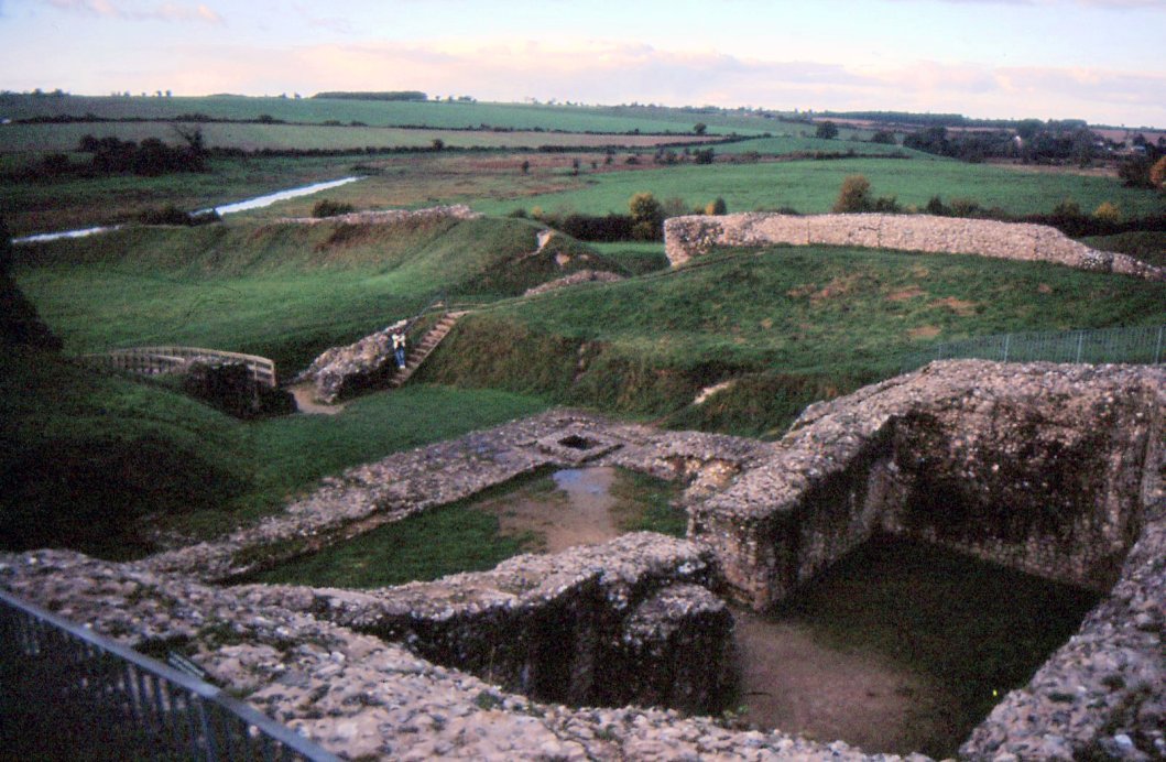
The remains of Castle Acre lie just north of the River Nar and consist
of a roughly circular ringwork with an adjoining bailey to the south,
reinforced by a triangular barbican to the east. The ringwork is
approximately 180' in summit diameter and surrounded by a ditch which
varies from 10' to 15' in depth and marks the 300' basal diameter of
the ringwork. The bailey is almost 300' square from curtain to
curtain.
The first stonework on the site would appear to be a rectangular hall,
about 80' by 75' with walls 6' thick, built in the centre of the
original, low ringwork. This had a bank some 10' high to the
north, but only 6' to the south. The hall originally had at least
2 storeys and was divided by an internal east to west cross wall.
At some point the house was converted into a keep by blocking the
ground floor openings and doubling the thickness of the walls with
additional interior walls. Similar actions were taken at Portchester castle keep, while Harlech castle
too had its enceinte wall thickness doubled to make the works more
defensible. No attempt was made to integrate the wall joints at
Castle Acre, presumably as they would never be seen and the purpose of
the new inner walls was to give stability to the structure raised above
the old hall to convert it into a tall tower keep. The
simultaneous raising of the ringwork bank seems also to have
necessitated the raising of the tower interior. Consequently a
new ground level was made by dumping 5' of material on the old
floor. At some 80' square the tower keep was 10' larger than Rochester keep,
although it was probably never more than 50' high - enough to dominate
the raised ringwork curtain. This would have made it similar in
height to nearby Castle Rising.
Later again the keep was fundamentally altered, possibly before it was
even completed. Then the southern half was demolished, the spine
wall being strengthened and refaced to form a hall-shaped keep, while
the curtain was raised in height again. The shrinking of the keep
may have been done to enable the tower to be raised in height to over
60', the height that was probably needed to overshadow the newly raised
ringwork curtain.
Entrance to the initial ringwork was via a wooden gatetower to the
south whose plan was partially recovered by excavation. Later
this was replaced by the present projecting stone gatetower. This
is largely down to its foundations now, although one arch springer
survives on its west side. At a later date the gateway was
modified with the raising of the threshold due to the raising of the
ringwork interior and the partial blocking of the gate passageway to
make entrance more restricted. Possibly the gatetower was built
at the same time as the curtain wall was constructed. Later the
ringwork bank was raised in height again by another 6' and another
flint curtain wall, some 7' thick, was built on top of the earlier one,
possibly at the same time as the keep had its southern half
demolished. This left the top of the ringwork bank some 30' above
original ground level and raised the interior of the ringwork to the
first floor of the keep. To the north the last curtain wall still
stands to parapet height and is decorated externally by pilaster
buttresses. Such buttresses tend to be early, so this would
suggest that the building and halving of the keep happened over a
relatively short period. To the north-east of the ringwork is a
small rectangular buttress pierced by a vaulted passage. Possibly
this was a postern. Excavation showed that the ringwork curtain
to the north and west were lined with timber framed buildings,
similarly to what would be expected in a shell keep, viz. Restormal.
Judging from engravings, by the eighteenth century all trace of he keep
had disappeared raising the possibility that it was demolished, rather
than just left to decay.
The bailey would appear to have been walled at an early stage, as
evidenced by the curtain to the south as well as the east and west
gatehouses on current ground level. Like the ringwork the
enceinte to the east and west has been later raised, presumably to
enhance their defensive power. Similarly it would appear that a
new curtain was built on top of the older ones when they were buried
under the new ramparts. The southern curtain is externally faced
with coursed flint and includes a rectangular opening which probably
marks a south gate. Excavation has shown that there was once a
southern moat to the bailey before the River Nar, but that this has
been infilled.
An eastern and western gatehouse provided entry to the outer bailey at
ground floor level, both being commanded by the ringwork to the north.
The western gatehouse had 2 D shaped towers on the outer face
which made it similar to the surviving northern town gate in style and
possibly also in age. Internally parts of the lower jambs of the
gateway survive with some ashlar facing. Within this are the
grooves of a portcullis. Just north of the gatehouse is the base
of a garderobe which once served the upper floor. The eastern
gatehouse was much inferior to its town counterpart, which suggests
that the barbican was once a powerful structure. This was reached
via a wooden bridge and its great bank still suggests traces of a
medieval curtain wall.
There remains the powerful foundations of 3 buildings in the centre of
the outer bailey. These are thought to have been a great hall
with a solar at the east end, a small, square, detached kitchen and
possibly a chapel to the north. It has been logically suggested
that the hall replaced the house in the inner bailey, after its
conversion into a keep in the mid twelfth century. Presumably
this too was abandoned by the fourteenth century.
Town
The planned town, which presumably did not exist as a part of West Acre
in the Domesday Book, occupied a rectangular area some 750' north to
south by 600' east to west and lay immediately west of the
castle. It was enclosed by a wall set on a bank 10' high and
protected by a 50' wide and 10' deep ditch. This enclosure had
gates on the north and south sides. Where there are natural
defences, ie towards the river to the south and a scarp to the west,
the defences are much less strong. Unfortunately only the bank
and ditch on the west side and along much of the south side survive as
substantial earthworks now called Dyke Hills. The north gate has
survived remarkably intact as a gatetower with twin projecting solid
round turrets protecting a portcullis. Otherwise little remains
standing of the town wall except for at the eastern end of the south
side, where some fragments remain blocking the castle ditch.
Copyright©2021
Paul Martin Remfry