Burgh
The 'castle' at Burgh is thought to have originated as
one of the Roman forts of the Saxon Shore. It may have been
mentioned as Garianonum in the late Roman period in Britain, the name possibly derived from the River Gariennos
of Ptolemy (d.c.170AD). This is now known as the River Yare and
joins the Waveney just north of the fort. The history of the
Roman site must be mainly worked out from the 183 unstratified coins
found at the site. These range in age from Domitian (81-96) to
Honorius (395-423). Although 30 of these were illegible, the next
30 examples take the coin record from Domitian up to the start of the
reign of Constantine (306-337). The other 123 coins date from 306
to 423 AD with there being a definite spike in numbers in the early
320s. This might suggest that the fort was built some time after
the crushing of the rebel Allectus in 296 by Constantius and certainly
by the end of the reign of the Emperor Constantine (306-37AD).
The evidence suggests that the fort was abandoned in the early fifth
century, but like Pevensey, it
might have lived on in a cashless society that has left little
trace. To support this supposition, the pottery finds also seem
to run from the late third century onwards. The fortress itself
and its garrison of late Roman cavalry (equites stablesiani)
of the Notitia Dignitatum (dated to 400-425 AD) suggests it was still
functioning in the early fifth century. Certainly the coin record
continues within the fort with a silver sceatta of c.700AD and another
of King Ceowulf of the Mercians, Kent and East Anglia (821, deposed
823).
Burgh castle, like Caister on Sea, has been associated with the Cnobersburgh
mentioned by Bede (d.735) as a possession of King Sigebert of East
Anglia (c.631-635AD). This has him build the monastery for the
Irishman Fursa on a site:
pleasantly situated close to the woods and the sea in a castle (castro)
which in English is called Cnobheresburg, ie the city of
Cnobheri. Later King Anna of that realm with many noblemen
adorned it with more stately buildings and more splendid donations.
King Anna died in 653/4. Wattle and daub huts excavated in the
north part of the fort overlying the Romano-British huts found with
substantial quantities of Ipswich ware are thought to have been
remnants of this. Early churches were also founded in the old
Roman forts of Bradwell, Reculver, Richborough and just possibly Walton which may have been Dommoc, although this is usually thought to be Dunwich.
Burgh fort belonged to Bishop Stigand of Norwich under Edward the
Confessor (1042-66) and was a parcel of the 4 carucates that made up
the manor which also contained a church, the whole manor being worth
100s. By 1086 the manor of Burch was held by Ralph the
crossbowman (Balistarii) and
was worth 106s. Ralph also held 4 other vills lying south and
south-east of Burgh forming an arc towards Lowerstoft. Presumably
Ralph was the ancestor of the Burgh family of whom another Ralph held
Burgh for the sergeanty of finding a crossbowman for 40 days by
1212. By 1246 his grandson, another Ralph, had granted the manor
to Gilbert Wesenham who in turn passed the land on to Bromholm priory
in Norfolk. From this it would appear that the castle was no
longer a going concern by the thirteenth century.
Description
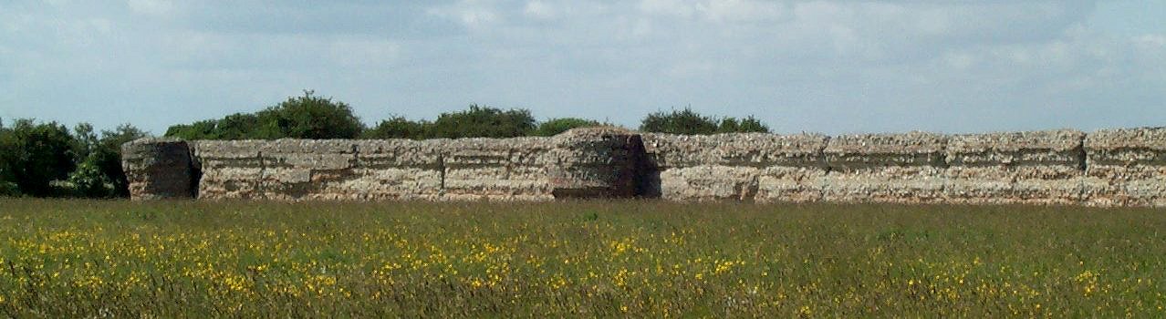
Burgh Roman fort stands hard against the muddy banks of the River
Waveney in Suffolk which runs past some 30' below the interior of the
fort. In fact, perhaps as much as half of it has been washed away
to the west, leaving a site 640' long by 410' wide. Of the
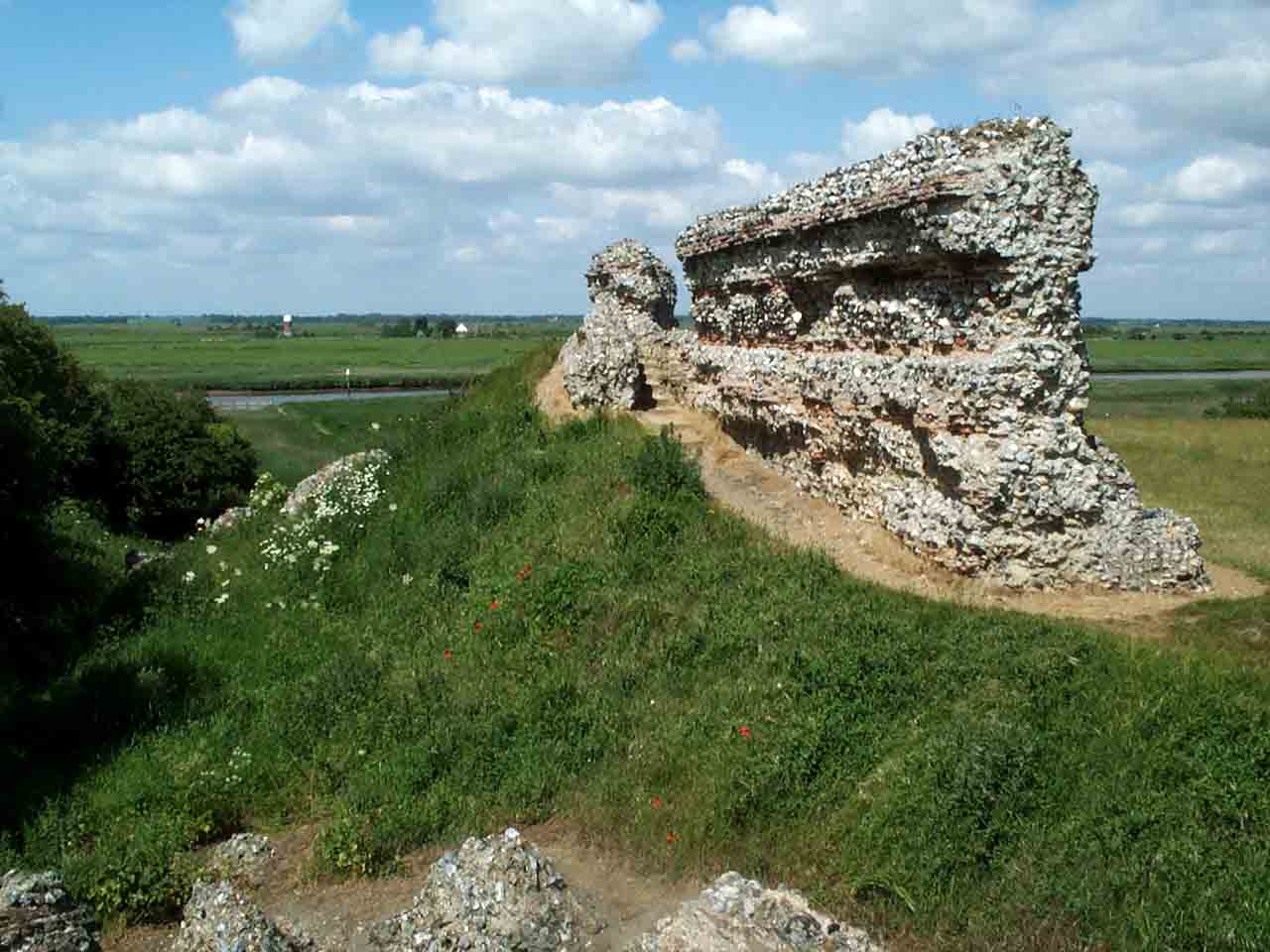
remainder the east side still carries the remnants of 4 boldly
projecting, 15' diameter, round towers, 2 equidistantly placed from the
destroyed east gate and 2 at the chamfered off corners. Presuming
the fort had similar north and south walls only 1 of the equidistant
towers remains to the north, while that to the south, like the main
gates, have fallen, although the remains of the single tower still lies
on its side, giving good access to the hollow in its central
core. The towers at first appear to have been added to the
defences as the lower 7' of their construction is not bonded to the
wall. However, although only the upper halves are bonded, the
tile lines appear at similar levels throughout and the towers have not
settled differently to the walls, as would have been expected if they
were of different phases. Therefore it seems that the first 7'
were not bonded as the foundations were known to have been insufficient
and the builders did not want to strain the walls until the first
building phase of 7' had completed. Consequently they left the
lower portions of the towers unbonded. The 2' diameter holes, 2'
deep in the centre of the towers, are thought to have been an aid in
mounting war engines, maybe for swivelling powerful crossbows, although
the narrow diameter of the towers, only 15', would make them cramped to
operate. The only surviving gate, the east one, is now just a
featureless gap. However, excavation in the 1850's found some 2'
thick walls running back from the 11½' wide gate. These
are now interpreted as the sides of 2 internal guard rooms which may
have made an internal gatetower.
The fort walls still stand over 15' high and some 10' thick. They
are a mixture of coursed flint rubble set between regular 3 courses of tile in
typical Roman fashion. This style is repeated in the Roman defences at
Colchester, Dover lighthouse (one or 2 tile courses) Lincoln, London,
Lympne (2 tile courses), Pevensey (twin tile courses), Portchester
(twin tile courses), Richborough (twin tile courses), Silchester (twin
flat stone courses), Venta Icenorum and probably Walton. Such a
tile reinforced style seems confined to areas of poor quality building stone,
like flints and so is not present in sandstone or limestone built forts
like those along Hadrian's Wall, or surprisingly Chichester which is
flint built, but without tiles.
The remnant of the south wall at Burgh is much collapsed, but at the
south-west corner of the present site are the shattered remnants of a
castle motte, demolished around 1770 and levelled in 1839. This
was protected by a V shaped ditch which has been infilled. The
ditch enclosed a motte with a diameter of some 235' north to south by
170' east to west. Excavation found it had been 13' deep and wet,
presumably fed by the nearby river. Clay pads disturbed Saxon
graves and slots in a separate wall fragment were thought to be where a
substructure once stood to help stabilise the motte so that it could
carry a timber Norman tower. Radio-carbon dating of the bones in
the Saxon graves returned results dating from 630 to 1170 which might
suggest the fort was used as a Saxon graveyard from the seventh century
until the Norman Conquest. Certainly the late dating bone sample
which returned 810-1170 was from a grave that had disturbed an early
burial.
Copyright©2020
Paul Martin Remfry